Fall Creek (Middle Fork Willamette River tributary)
.JPG)
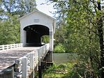
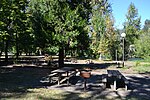
Fall Creek is a 34-mile (55 km) tributary of the Middle Fork Willamette River in Lane County in the U.S. state of Oregon. Beginning in the Cascade Range, the creek flows generally west through the Willamette National Forest to enter the Middle Fork upstream of Jasper, southeast of Springfield and Eugene.Along its upper and middle reaches, the creek flows by many campgrounds, picnic sites, a state park, and the Fall Creek National National Recreation Trail. Fall Creek Reservoir is a man-made reservoir where the stream is impounded by Fall Creek Dam. Below the dam, the small communities of Unity and Fall Creek lie along the lower reaches. Two covered bridges carry rural roads over the creek, one at Unity and the other further downstream.
Excerpt from the Wikipedia article Fall Creek (Middle Fork Willamette River tributary) (License: CC BY-SA 3.0, Authors, Images).Fall Creek (Middle Fork Willamette River tributary)
Jasper Lowell Road,
Geographical coordinates (GPS) Address Nearby Places Show on map
 Continue reading on Wikipedia
 Geographical coordinates (GPS)
| Latitude | Longitude |
|---|---|
| N 43.970555555556 ° | E -122.86944444444 ° |
Address
Jasper Lowell Road
Jasper Lowell Road
97455
Oregon, United States
Open on Google Maps