Rhuallt
Villages in Denbighshire

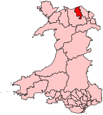
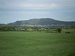
Rhuallt is a village in Denbighshire, Wales. The village is situated approximately 5 mi (8.0 km) south of Prestatyn and 2 mi (3.2 km) east of St Asaph on the B5429 road, adjacent to the A55, and has a caravan site. There is one public house, The White House. Another public house, The Smithy Arms, closed permanently in or around 2014. Some elements of village life in Rhuallt were described in the BBC Domesday Project of 1986. Rhuallt is mostly in the community of Tremeirchion, with some outlying parts in Cwm, Denbighshire.
Excerpt from the Wikipedia article Rhuallt (License: CC BY-SA 3.0, Authors, Images).Rhuallt
B5429,
Geographical coordinates (GPS) Address Nearby Places Show on map
Geographical coordinates (GPS)
| Latitude | Longitude |
|---|---|
| N 53.264 ° | E -3.389 ° |
Address
B5429
LL17 0TE , Tremeirchion
Wales, United Kingdom
Open on Google Maps


