Elgin Crescent
Notting HillPages containing links to subscription-only contentStreets in the Royal Borough of Kensington and ChelseaUse British English from January 2017

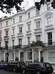
Elgin Crescent is a street in Notting Hill, London, England. It runs west from Portobello Road, crosses Ladbroke Grove and at its south-western end joins Clarendon Road. The section between Portobello Road and Kensington Park Road is formed of shops, cafes and restaurants, whilst the remainder is residential.The houses were built in the 1850s and 1860s, and most share communal gardens. Many are now listed buildings. East of Ladbroke Grove, it was originally called Elgin Road. It is named after the town of Elgin in Scotland.
Excerpt from the Wikipedia article Elgin Crescent (License: CC BY-SA 3.0, Authors, Images).Elgin Crescent
Elgin Crescent, London Notting Hill (Royal Borough of Kensington and Chelsea)
Geographical coordinates (GPS) Address Nearby Places Show on map
Geographical coordinates (GPS)
| Latitude | Longitude |
|---|---|
| N 51.514166666667 ° | E -0.20805555555556 ° |
Address
Elgin Crescent 50
W11 2HB London, Notting Hill (Royal Borough of Kensington and Chelsea)
England, United Kingdom
Open on Google Maps


