place

Stadion an der Bremer Brücke
1933 establishments in GermanyBuildings and structures in OsnabrückFootball venues in GermanyGerman sports venue stubsLower Saxony building and structure stubs
Sports venues completed in 1933Sports venues in Lower SaxonyUEFA Women's Championship final stadiumsVfL Osnabrück
Bremer bruecke
Bremer bruecke

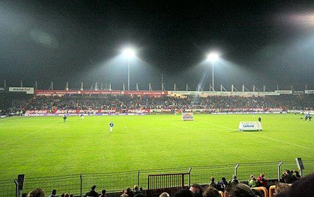
Stadion an der Bremer Brücke or Bremer Brücke is a football stadium in the Schinkel district of Osnabrück, Germany. It is used mostly for football matches and is the home stadium of VfL Osnabrück. The stadium currently holds 16,100 people and was opened in 1933. From the 1970s, the stadium consisted of the Grandstand ("South Stand"), two roofed terraces behind the goals ("East Stand" and "West Stand"), and an uncovered terrace opposing the grandstand ("North Stand"). On 1 April 2008, demolishing works of the very old North Stand started to make way for a modern entirely roofed stand to be built at the site. The new stand was opened in August 2008; however, there has been controversy with a local resident whose property is situated very close to the ground. For this reason, the stand could not be fully completed earlier than 2011. With the construction of the new stand, the overall stadium capacity decreased to 16,667, but seating capacity rose to 6,192. The name, which can be translated as "Stadium at Bremen Bridge", comes from a neighbouring railway bridge of the Osnabrück–Bremen railway line. In 2004, a local telecommunications company, Osnatel, bought the naming rights for the stadium and it was renamed to "Osnatel Arena". When the contract expired in 2016, the stadium got back its traditional name.

Excerpt from the Wikipedia article Stadion an der Bremer Brücke (License: CC BY-SA 3.0, Authors, Images).

Stadion an der Bremer Brücke
Hannes-Haferkamp-Platz, Osnabrück Schinkel

Geographical coordinates (GPS) Address Website External links Nearby Places
placeShow on map

Wikipedia: Stadion an der Bremer BrückeContinue reading on Wikipedia

Geographical coordinates (GPS)

Latitude Longitude
N 52.280833333333 ° E 8.0711111111111 °
placeShow on map

Address

Stadion an der Bremer Brücke

Hannes-Haferkamp-Platz 1
49084 Osnabrück, Schinkel
Lower Saxony, Germany
mapOpen on Google Maps

Website
vfl.de

linkVisit website

linkWikiData (Q265199)
linkOpenStreetMap (181867737)

Bremer bruecke
Bremer bruecke
Share experience

Nearby Places

Fledder
Fledder

Fledder is a district in the east of Osnabrück, Germany, characterised by its large prevalence of industrial estates. Despite being the location of numerous businesses and large supermarkets the district has comparatively few residential buildings; its population is roughly 2,400. In 1912, a centrally located shunting yard was set up between the factory of the car manufacturer Karmann and the former Klöckner steelworks. It was substantially expanded and modernised during the 1960s, however its overall capacity soon became insufficient. In 1962, the Fledder district was formally designated an industrial zone by the city council of Osnabrück. The idea of transforming the area into a cohesive wholesale centre originally came from Dr. Hans—Achim Kastan, leader of the wholesale association. After Osnabrück's old wholesaling quarter – situated between the main train station and the city centre – was dissected by the extension of the inner ring road causing mounting transport problems. At the beginning of the 1960s, Dr. Castan began to devise plans for a new wholesale centre based in Fledder. Following long-lasting negotiations with – among others - the city council regarding property matters and plans for development, the wholesalers themselves who needed to be won over to the project, and also with the Federal Ministry of Economics and credit institutes regarding issues of financing, Castan was able to guarantee relatively fast development of the wholesale centre. Numerous businesses were quick to settle in the area afterwards, necessitating a railway siding as well as road links. This led to further expansion of the shunting yard. The haulage and logistics firm Meyer & Meyer is based in Fledder – founded in 1902, it employs around 2,300 people today. The district's name links back to the old term used for the lowland area to the southwest of the city centre. Due to its lowness and moisture, this area was only used for pasturage. The term "Fladder" was used to denote such moorland only thinly covered with soil. Locally the area tends to be referred to as der Fledder (the Fledder). There is a round bunker from World War II located on Schellenbergstraße near the Schellenbergbrücke. The surrounding area is today the property of Karmann. In addition, there was also an air-raid protection tower known as Kiebitzheide, which was eventually pulled down. An old high-rise bunker still stands on the corner of Stahlwerksweg and Bielefelder Straße; today various businesses use it for office space and workshops. Fledder is also home to two mosques.

Osnabrück
Osnabrück

Osnabrück (German pronunciation: [ɔsnaˈbʁʏk] (listen); Westphalian: Ossenbrügge; archaic Osnaburg) is a city in the German state of Lower Saxony. It is situated on the river Hase in a valley penned between the Wiehen Hills and the northern tip of the Teutoburg Forest. With a population of 168,145 Osnabrück is one of the four largest cities in Lower Saxony. The city is the centrepoint of the Osnabrück Land region as well as the District of Osnabrück.The founding of Osnabrück was linked to its positioning on important European trading routes. Charlemagne founded the Diocese of Osnabrück in 780. The city was also a member of the Hanseatic League. At the end of the Thirty Years' War (1618–1648), one of the treaties comprising the Peace of Westphalia was negotiated in Osnabrück (the other being in nearby Münster). In recognition of its role as the site of negotiations, Osnabrück later adopted the title Friedensstadt ("city of peace"). The city is also known as the birthplace of anti-war novelist Erich-Maria Remarque and painter Felix Nussbaum. More recently Osnabrück has become well known for its industry. Numerous companies in the automobile, paper, steel and grocery sectors are located in the city and its surrounding area. In spite of the massive destruction inflicted on the city during World War II, the Altstadt (old town) was eventually reconstructed extensively with designs loyal to the original medieval architecture there. Osnabrück was also the home of the largest British garrison outside the United Kingdom. Osnabrück's modern, urban image is enhanced by the presence of more than 22,000 students studying at the University and the University of Applied Sciences. Although part of the state of Lower Saxony, historically, culturally and linguistically Osnabrück is considered part of the region of Westphalia.

Widukindland
Widukindland

Widukindland is a district of Osnabrück, Germany. It is situated in the north-east of the city, on the slopes of the Schinkelberg (Schinkel Hill). It arose from the former boundaries of Schinkel. The Freiheitsweg (Freedom Way) and the Heimatweg (Homeland Way) were built in 1922. This settlement north of Bremer Straße was transformed under Nazi rule in the 1930s into a small housing estate area. The zeitgeist of that era remains evident in the names of the district's streets today: for example “Vaterlandsweg” (Fatherland Way), “Kameradschaftsweg” (Comradeship Way), “Sigiburgweg” (Sigiburg Way), “Freiheitsweg” (Freedom Way), “Heimatweg” (Homeland Way), “Sachsenweg” (Saxon Way) and “Cheruskerweg” (Cherusci Way). During the planning stages, it was made sure that every house had a garden to promote self-sufficiency. Since 1977 the area has been home to an important telecommunications tower. The street “Freundschaftsweg” (Friendship Way) was built in 1953. This district, characterised by its prevalence of single-family homes, large gardens and wooded areas, covers an area of 271.1 hectares and is home to about 4,700 people. Good infrastructure is provided for its residents, namely: good public transport links (city bus lines 71, 72, E31 and Nachtbus (night bus) N7) good medical provisions (general practitioner, dentist, pharmacy, HHO treatment centre, ergotherapy practices) a primary school a youth centre (Jugend und Kultur im Widukindland e. V.) two denominational kindergartens and a children's store a Lutheran parish (Timotheus) a Catholic parish (St. Boniface) two sports clubs (TSV Widukindland, VfB Schinkel) local shops (bakery, fishmonger, florist etc.) service providers (garages, banks/savings banks, driving schools, hairdressers, beauticians, furniture dealerships, sanitary fitters) various restaurants (traditional/local, Japanese, Chinese, Italian) The Schinkelberg green belt and the Gartlage, along with several meadows and fields, give residents good opportunities for recreation. The district derives its name from the legendary Saxon duke Wittekind. Many of its streets and open spaces bear the names of notable Saxon tribes and also local personages.

Dodesheide
Dodesheide

Dodesheide is a town in the borough of Osnabrück, Germany; with a population of roughly 7,900 residents it is located to the north-east of the city. Its boundaries are delineated in the north by the Vehrter Landstraße, in the west by the landwehr – a former defensive line around the town consisting of a bank and ditches – in the south by the Sandbach and the Osnabrück-Bremen railway line; the city boundary itself marks its eastern border. It is made up of sections of the former districts of Schinkel and Haste. The district’s most significant building is the Haus Gartlage, a former Jesuit seat which some years ago was converted into residences. Apart from this and a number of farms, most of the developments in the Dodesheide district are from the 20th century. Since the 1950s, the construction of residential space following set construction stages has been systematically encouraged; one notable case is the “Dodeshaus” model building project from the 1960s, focused on the area between Haster Weg and Ellerstraße where primarily bungalows are situated. The eastern part of the district continues to be characterised by the barracks of the British army and the attached soldiers’ residences; their final withdrawal in 2009 led to expectations of extensive structural change in the area. There are two churches in Dodesheide: the Thomaskirche (Protestant) and the St. Franziskus Church (Catholic). At the beginning of the 1970s, the possibility of making Dodesheide the location of the planned University of Osnabrück was discussed; in the end, however, the district of Westerberg was chosen. Its main offices are located at the Schloss Osnabrück (Osnabrück Palace). A remnant of the planning from that time remains in the form of the Dodesheide student residence located on Mecklenburger Straße; with 206 residents it is today the second largest student residence in the town.The traditional perception of the name Dodesheide as linked to “Todesheide” (Death’s Heath) is most likely false. The name is assumed to derive from the Old German proper name “Dodo”: its proper meaning being “Dodos Heide” (Dodo’s Heath).

Innenstadt (Osnabrück district)

The Innenstadt (city centre) is the central district of the city of Osnabrück in Lower Saxony, Germany; its population is roughly 8,300. The Innenstadt comprises the medieval Altstadt (old town) and Neustadt (new town), which were united in 1306. The Altstadt developed around the town's three medieval churches, which initially constituted small parishes in the local area: the Lutheran Kirche St. Marien (Church of St. Mary), the Lutheran Kirche St. Katharinen (Church of St. Catherine) and the Dom St. Peter (St. Peter's Cathedral), which was the seat of the bishop. The Neustadt developed around the Kirche St. Johann (Church of St. John). Today the Gymnasialkirche and the Herz-Jesu-Kirche (Church of the Sacred Heart) are also part of the Innenstadt, as well as two mosques. The Schloss Osnabrück, formerly the residence of the local prince-bishop and today the head office of the University of Osnabrück, is also located here. This district is the economic heart of the city. The retail sector, with many outlets located along the extensive pedestrian precinct, is particularly prominent. Service industries are also present in the Innenstadt, including gastronomic outlets and hotels, public authorities and educational institutions. 94% of Osnabrück's Altstadt was destroyed during World War II. The Innenstadt is connected to the national and regional rail networks by the Osnabrück Hauptbahnhof (main station) and the Altstadt station (formerly Osnabrück-Hasetor). Another station used to operate at the Wittekindplatz: Osnabrück-West, also known as Osnabrück-Hannoverscher Bahnhof. The establishment of an Osnabrück-Johannistor train station to connect the Neustadt area has been a topic of discussion since the year 1895. The Innenstadt was also connected by three tram lines (first opened in 1906 and gradually expanded over time): tram line 1 from the Hauptbahnhof to the Heger Friedhof (Heger Cemetery) via Hauptpost and Nikolaiort, tram line 2 from Schölerberg to Haste via Johannistor (Rosenplatz), Neumarkt, Nikolaiort and Hasetor, and tram line 3 from Martiniplatz/Heinrich-Lübke-Platz to Schinkel via Neumarkt and Hauptpost. Present-day urban planning continues to consider the possibility of better connecting the Innenstadt area by means of an inner-city tram or light rail network.