Estuary of Bilbao
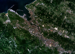
The Estuary of Bilbao (Spanish: Ría de Bilbao / Basque: Bilboko Itsasadarra) lies at the common mouth of the rivers Nervion, Ibaizabal and Cadagua, which drain most of Biscay and part of Alava in the Basque Country, Spain. In this instance, the Spanish word estuario is used to describe what in English would normally be called part estuary, part tidal river. The estuary becomes a tidal river which extends 16 km (9.9 mi) into the city of Bilbao, starting from the Bilbao Abra bay. It hosts the port of Bilbao throughout its length, although the Port Authority has recently restored most of the upper reaches to Bilbao and other municipalities for their urban regeneration. The port is now being transferred to the seaboard on the coast at Santurtzi and Zierbena. Downstream from Bilbao the river divides its metropolitan area in its left bank (Barakaldo, Sestao, Portugalete and Santurtzi) and right bank (Erandio, Leioa and Getxo).
Excerpt from the Wikipedia article Estuary of Bilbao (License: CC BY-SA 3.0, Authors).Estuary of Bilbao
Geographical coordinates (GPS) Address Nearby Places Show on map
Geographical coordinates (GPS)
| Latitude | Longitude |
|---|---|
| N 43.366666666667 ° | E -3.05 ° |
Address
Elexalde
48993 , Elexalde
Autonomous Community of the Basque Country, Spain
Open on Google Maps


