Donaukanal

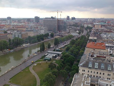
The Donaukanal ("Danube Canal") is a former arm of the river Danube, now regulated as a water channel (since 1598), within the city of Vienna, Austria. It is 17.3 kilometres (10.7 mi) long and, unlike the Danube itself, it borders Vienna's city centre, Innere Stadt, where the Wien River (Wienfluss) flows into it.The Donaukanal bifurcates from the main river at the Nußdorf weir and lock complex, in Döbling, and joins it again just upstream of the "Praterspitz", at the Prater park in Simmering. The island thus formed between the Donaukanal and the Danube holds two of the 23 districts of Vienna: Brigittenau (20th District) and Leopoldstadt (2nd District). The canal is crossed by fifteen road bridges and five rail bridges.Because in German, the name Kanal, which has been used since about 1700, evokes associations of an open sewer, attempts at renaming the Donaukanal have been made (one suggestion was Kleine Donau—Little Danube) but have not met with success.
Excerpt from the Wikipedia article Donaukanal (License: CC BY-SA 3.0, Authors, Images).Donaukanal
Franz-Josefs-Kai, Vienna Innere Stadt
Geographical coordinates (GPS) Address Nearby Places Show on map
Geographical coordinates (GPS)
| Latitude | Longitude |
|---|---|
| N 48.213055555556 ° | E 16.375277777778 ° |
Address
Franz-Josefs-Kai
Franz-Josefs-Kai
1010 Vienna, Innere Stadt
Austria
Open on Google Maps


