Cumorah

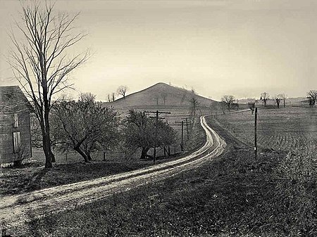
Cumorah (; also known as Mormon Hill, Gold Bible Hill, and Inspiration Point) is a drumlin in Palmyra, New York, United States, where Joseph Smith said he found a set of golden plates which he translated into English and published as the Book of Mormon. In the text of the Book of Mormon, "Cumorah" is a hill located in a land of the same name, which is "a land of many waters, rivers and fountains". In this hill, a Book of Mormon figure, Mormon, deposited a number of metal plates containing the record of his nation of Nephites, just prior to their final battle with the Lamanites in which at least 230,000 people were killed.Early Latter Day Saints assumed that the Cumorah in New York was the same Cumorah described in the Book of Mormon, based largely on a letter written by Oliver Cowdery (Letter VII), published in the July 1835 Messenger and Advocate and reprinted several times at the direction of Joseph Smith. In the early 20th century, scholars from the Reorganized Church of Jesus Christ of Latter Day Saints (RLDS Church) and the Church of Jesus Christ of Latter-day Saints (LDS Church) began to speculate that there were two such hills and that final battle in the Book of Mormon took place on a hill in southern Mexico, Central America, or South America. The LDS Church has no official position on the matter, and while these hypotheses are not held by some leaders and members of the LDS Church, they are firmly espoused by others.In the official account of Joseph Smith it is stated that Manchester, Ontario County, New York, is the location of the encounter with Angel Moroni.
Excerpt from the Wikipedia article Cumorah (License: CC BY-SA 3.0, Authors, Images).Cumorah
North Main Street,
Geographical coordinates (GPS) Address Nearby Places Show on map
Geographical coordinates (GPS)
| Latitude | Longitude |
|---|---|
| N 42.9945075 ° | E -77.2202583 ° |
Address
North Main Street 935
14548
New York, United States
Open on Google Maps


