place

Big Indian station

Demolished railway stations in the United StatesFormer Ulster and Delaware Railroad stationsFormer railway stations in New York (state)New York (state) railway station stubsPages with no open date in Infobox station
Railway stations in Ulster County, New YorkRailway stations in the Catskill MountainsRailway stations in the United States closed in 1954
Big indian station
Big indian station

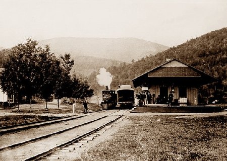
The station at Big Indian, MP 36.4, was another Ulster and Delaware Railroad station. It served the town of Big Indian, New York, and was at the bottom of the Pine Hill Grade. At this stop, a second or third locomotive was coupled to the train to help it up the grade to Grand Hotel station. A water tower was located here along with a turntable for turning steam locomotives. This station saw its last train in 1954, when the station was closed down and abandoned. This station survived until being razed by the State of New York during the reconstruction of Route 28 in the late 1960s. All that is left on the station grounds that shows that anything was there is a rather barren area next to the Big Indian Post Office. A careful observer can also locate the base of the old water tower south of the railroad and west of Route 28. The tracks that run adjacent to the former station site are now leased to the Catskill Mountain Railroad.

Excerpt from the Wikipedia article Big Indian station (License: CC BY-SA 3.0, Authors, Images).

Big Indian station
Oliverea Road,

Geographical coordinates (GPS) Address Nearby Places
placeShow on map

Wikipedia: Big Indian stationContinue reading on Wikipedia

Geographical coordinates (GPS)

Latitude Longitude
N 42.1025 ° E -74.445277777778 °
placeShow on map

Address

Oliverea Road 34
12410
New York, United States
mapOpen on Google Maps

Big indian station
Big indian station
Share experience

Nearby Places

Balsam Mountain (Ulster County, New York)

Balsam Mountain is one of the High Peaks of the Catskill Mountains in the U.S. state of New York. Its exact height has not been determined, so the highest contour line, 3,600 feet (1,100 m), is usually given as its elevation. It is located in western Ulster County, on the divide between the Hudson and Delaware watersheds. The summit and western slopes of the peak are within the Town of Hardenburgh and its eastern slopes are in Shandaken. The small community of Oliverea is near its base on that side. Most of the mountain is publicly owned, managed by the New York State Department of Environmental Conservation as part of the state Forest Preserve, part of the Big Indian-Beaverkill Range Wilderness Area in the Catskill Park. The summit is on a small corner of private land. As one of the High Peaks it is a popular destination for hikers, especially peakbaggers seeking membership in the Catskill Mountain 3500 Club, since along with Slide, Panther and Blackhead it is one of four peaks that members must climb twice, at least once in winter. The Pine Hill-West Branch Trail (PHWB) crosses its summit; hikers usually approach from either side via the Oliverea-Mapledale Trail, which intersects the PHWB south of the summit, and make the ascent from there. The northwestern approach makes a loop route possible via the Mine Hollow Trail; the southeastern ascent, from McKenley Hollow, has the steepest stretch of trail on any ascent of a Catskill High Peak.