Sloane Square

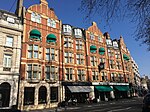
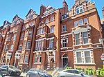
Sloane Square is a small hard-landscaped square on the boundaries of the central London districts of Belgravia and Chelsea, located 1.8 miles (2.9 km) southwest of Charing Cross, in the Royal Borough of Kensington and Chelsea. The area forms a boundary between the two largest aristocratic estates in London, the Grosvenor Estate and the Cadogan. The square was formerly known as 'Hans Town', laid out in 1771 to a plan of by Henry Holland Snr. and Henry Holland Jnr. Both the square and Hans Town were named after Sir Hans Sloane (1660–1753), an Anglo-Irish doctor who, jointly with his appointed trustees, owned the land at the time.
Excerpt from the Wikipedia article Sloane Square (License: CC BY-SA 3.0, Authors, Images).Sloane Square
Sloane Square, London Chelsea (Royal Borough of Kensington and Chelsea)
Geographical coordinates (GPS) Address Nearby Places Show on map
Geographical coordinates (GPS)
| Latitude | Longitude |
|---|---|
| N 51.492521 ° | E -0.157188 ° |
Address
Chelsea war monument
Sloane Square
SW1W 8AX London, Chelsea (Royal Borough of Kensington and Chelsea)
England, United Kingdom
Open on Google Maps
