place

Arneys Mount, New Jersey

Burlington County, New Jersey geography stubsSpringfield Township, Burlington County, New JerseyUnincorporated communities in Burlington County, New JerseyUnincorporated communities in New JerseyUse American English from July 2023
Use mdy dates from July 2023
Arney's Mount Friends Meetinghouse & Burial Ground (2)

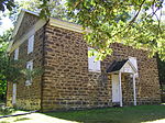
Arneys Mount is an unincorporated community located within Springfield Township in Burlington County, in the U.S. state of New Jersey. It shares its name with an adjacent hill, Arneys Mount, the highest point in Burlington County. Arney's Mount Friends Meetinghouse and Burial Ground were added to the National Register of Historic Places in 1973.

Excerpt from the Wikipedia article Arneys Mount, New Jersey (License: CC BY-SA 3.0, Authors, Images).

Arneys Mount, New Jersey
Arney's Mount Road,

Geographical coordinates (GPS) Address Nearby Places
placeShow on map

Wikipedia: Arneys Mount, New JerseyContinue reading on Wikipedia

Geographical coordinates (GPS)

Latitude Longitude
N 40.009722222222 ° E -74.696666666667 °
placeShow on map

Address

Arney's Mount Road 297
08068
New Jersey, United States
mapOpen on Google Maps

Arney's Mount Friends Meetinghouse & Burial Ground (2)
Share experience

Nearby Places

Springfield Township School District (New Jersey)

The Springfield Township School District is a community public school district that serves students in pre-kindergarten through sixth grade from Springfield Township in Burlington County, New Jersey, United States.As of the 2018–19 school year, the district, comprising one school, had an enrollment of 226 students and 22.7 classroom teachers (on an FTE basis), for a student–teacher ratio of 10.0:1.The district is classified by the New Jersey Department of Education as being in District Factor Group "FG", the fourth-highest of eight groupings. District Factor Groups organize districts statewide to allow comparison by common socioeconomic characteristics of the local districts. From lowest socioeconomic status to highest, the categories are A, B, CD, DE, FG, GH, I and J.Public school students in seventh through twelfth grades attend the schools of the Northern Burlington County Regional School District, which also serves students from Chesterfield Township, Mansfield Township, North Hanover Township, along with children of military personnel based at Joint Base McGuire–Dix–Lakehurst. As of the 2018–19 school year, the high school district, comprising two schools, had an enrollment of 2,190 students and 163.4 classroom teachers (on an FTE basis), for a student–teacher ratio of 13.4:1. The schools in the district (with 2018–19 enrollment data from the National Center for Education Statistics) are Northern Burlington County Regional Middle School with 811 students in grades 7 - 8 and Northern Burlington County Regional High School with 1,348 students in grades 9-12. Both schools are in the Columbus section of Mansfield Township. Using a formula that reflects the population and the value of the assessed property in each of the constituent municipalities, taxpayers in Springfield Township pay 17.7% of the district's tax levy, with the district's 2013-14 budget including $35.6 million in spending.

Laornis

Laornis is a genus of a prehistoric neornithine birds, known only from Specimen YPM 820, a single tibiotarsus leg bone discovered in the late 19th century. Consequently, the genus is monotypic, containing only the species Laornis edvardsianus. Regarding its scientific name, Laornis means "stone bird", from Ancient Greek lao "stone" + ornis "bird". edvardsianus honors Alphonse Milne-Edwards, to compliment the French paleontologist on his landmark study Recherches Anatomiques et Paleontologiques pour servir a l'Histoire des Oiseaux Fossiles de la France, the second part of which was nearing completion at that time.It was found in Late Cretaceous or Early Paleocene sediments of the Hornerstown Formation at the Birmingham Marl Pits, Pemberton Township, New Jersey, United States (39°59'N, 74°43'W). The deposits were laid down at about 66–63 Ma (million years ago). The bone is rather distinct but not very diagnostic. Its general shape suggests that Laornis was a semi-aquatic bird with longish legs and a body at least the size of a large goose. It may have been a wading bird, in which case it stood probably around one meter (3–4 ft) tall in life, depending on how long its legs and neck were exactly, which of course cannot be told from the one known bone. On the other hand, it might have been a larger seabird with proportionally shorter legs.It has variously been allied with the Charadriiformes and the Gruiformes, and is tentatively placed in a family of its own, Laornithidae. It may be considered some kind of basal gruiform, or more probably part of an ancestral lineage related to the common ancestor of gruiform, charadriiform, and/or any or all other modern "wading" bird families. It might have been one of the extinct stilt-legged waterfowl of the Presbyornithidae, and it cannot even be excluded that it was an ancient pseudotooth bird, seabirds of unclear affiliation that evolved to immense proportions in the Neogene but by the time of Laornis probably were mostly the size of a large petrel.