place

Paulsgrove

Areas of PortsmouthHousing estates in HampshireUse British English from November 2012
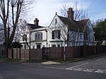
St Michael and All Angels Church, Hempsted Road, Paulsgrove (August 2017) (2)

Paulsgrove is an area of northern Portsmouth, Hampshire, England. Initially a small independent hamlet for many centuries, it was admitted to the city limits in 1920 and grew rapidly after the end of the Second World War.

Excerpt from the Wikipedia article Paulsgrove (License: CC BY-SA 3.0, Authors, Images).

Paulsgrove
Allaway Avenue, Portsmouth Paulsgrove

Geographical coordinates (GPS) Address Nearby Places
placeShow on map

Wikipedia: PaulsgroveContinue reading on Wikipedia

Geographical coordinates (GPS)

Latitude Longitude
N 50.849308 ° E -1.093136 °
placeShow on map

Address

Beacon View Primary Academy

Allaway Avenue
PO6 3PS Portsmouth, Paulsgrove
England, United Kingdom
mapOpen on Google Maps

St Michael and All Angels Church, Hempsted Road, Paulsgrove (August 2017) (2)
Share experience

Nearby Places

Paulsgrove Halt railway station

Paulsgrove Halt was a railway station opened in 1928 to serve the adjacent Portsmouth Racecourse, a pony racing stronghold. The racecourse, and station, lay in the Paulsgrove district of Portsmouth, southern England, rather than the modern area now known as Wymering. The station was located on the West Coastway Line between Cosham and Portchester, and generated substantial income within the area.The funding for the station, along with that for the racecourse, was provided by local businessman George Cooper, who lived at nearby Paulsgrove House and was a keen sports fan. The station was built in the style of a halt rather than a full station. The station closed along with the racecourse when the land was acquired by the military in 1939, at the outbreak of World War II; it was to be used as an ammunition dump. Since the end of World War II the area has been developed for housing and there have been a number of attempts made to open a station on the same site. Provision for a station has been included in the Local Development Plan of the City of Portsmouth for many years. On 26 October 2007, Portsmouth F.C. announced plans to relocate to a new 36,000-seat stadium on Horsea Island, which is situated to the south of the former station site. As part of the stadium plans, they are drawing up an integrated transport policy which includes examining the feasibility of opening a station. South West Trains indicated on 29 October 2007, via an interview in the Portsmouth News, that the club's plan may generate sufficient business, even if the station was only opened on match days, for them to consider a further study should the club wish to proceed.

Portsdown Hill
Portsdown Hill

Portsdown Hill is a long chalk ridge in Hampshire, England. The highest point of the hill lies within Fort Southwick at 131m above sea level. The ridge offers good views to the south over Portsmouth, the Solent, Hayling Island and Gosport, with the Isle of Wight beyond. The hill is on the mainland, just to the north of Ports Creek, which separates the mainland from Portsea Island, on which lies the main part of the city of Portsmouth, one of the United Kingdom's main naval bases. To the north lies the Forest of Bere, with the South Downs visible in the distance. Butser Hill can be seen on a clear day. The hill is formed from an inlier of chalk which has been brought to the surface by an east–west upfold of the local strata known as the Portsdown Anticline.Southwick House is close by the north side of the hill, the HQ for U.S. General Dwight D. Eisenhower during the D-Day invasions; the generals prayed together before D-Day at Christ Church Portsdown, on the hill, which has a memorial window. The A3(M) motorway cuts through the east side of the hill while the original A3 climbs over the centre by the George Inn pub and Christ Church. The nearest railway stations (from west to east) are Portchester, Cosham and Bedhampton. There are many stories about real and imagined tunnels in the hill. The area contains active military research establishments, including one of the core sites of Dstl (known as Dstl Portsdown West) and sites run by QinetiQ. Part of the hill has been designated a Site of Special Scientific Interest. Most of the southern flank of the ridge is designated as access land under the Countryside and Rights of Way Act 2000 and thereby freely available for the public to enjoy on foot.During the early part of the English Civil War, Royalist forces from Portsmouth were involved in a number of skirmishes with Parliamentarians on the hill In the Victorian era the hill was home to a fair on Easter Mondays.