place

Benington High Wood

Benington, HertfordshireForests and woodlands of HertfordshireSites of Special Scientific Interest in Hertfordshire
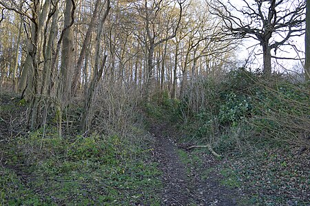
Benington High Wood 1

Benington High Wood is a 20.7-hectare (51-acre) biological Site of Special Scientific Interest in Benington, Hertfordshire. The planning authority is East Hertfordshire District Council.The site is ancient woodland, described by Natural England as "one of the best remaining examples in the county of the pedunculate oak-hornbeam of the ash-maple variety". Shrub species include field maple and hazel, with a higher ground flora diversity in clearings and rides.There is access from a footpath between Walkern Road and Lordship Farm.

Excerpt from the Wikipedia article Benington High Wood (License: CC BY-SA 3.0, Authors, Images).

Benington High Wood
Walkern Road, East Hertfordshire Benington

Geographical coordinates (GPS) Address Nearby Places
placeShow on map

Wikipedia: Benington High WoodContinue reading on Wikipedia

Geographical coordinates (GPS)

Latitude Longitude
N 51.8952 ° E -0.1339 °
placeShow on map

Address

Walkern Road

Walkern Road
SG14 3RN East Hertfordshire, Benington
England, United Kingdom
mapOpen on Google Maps

Benington High Wood 1
Share experience

Nearby Places

A602 road
A602 road

The A602 is a road linking Hitchin in Hertfordshire, England, with A10 at Ware in Hertfordshire, via Stevenage. The course of the road has changed significantly since the 1960s with the construction of several bypasses and relief roads. In Hitchin, the road starts at a junction with the A505, and follows a relief road round the south of the town centre, before re-joining the course of the original route for 0.9 miles (1.4 km). The village of Little Wymondley is bypassed by a dual carriageway route to the A1 junction at Corey's Mill. In Stevenage, the road takes two courses through the town – the first is a concurrency with the A1 round the new town to the junction at Langley Sidings. The second is a route through the town itself, following closely the route of the old Great North Road. The two routes converge and form a northern bypass for the suburb of Broadwater (the old Hertford Road through Broadwater has been closed to motor vehicles since the 1990s, to prevent rat-running). The next 3 km of road is the only remaining original piece of the route, travelling through the villages of Bragbury End and Hooks Cross. The next feature is a roundabout, and the road once again diverges from its original course and takes a left to bypass the village of Watton-at-Stone. At the eastern end of the Watton-at-Stone bypass (constructed in the late 1980s) it reaches another roundabout. In the 1970s, the road continued from this point straight ahead down what is now the A119 to Hertford, and then travelled along the course of what is now the B1197 through Hertford Heath to Hoddesdon. With the opening of the A10 Hoddesdon and Ware bypass in the late 1970s, the A602 temporarily terminated at the A414 in Hertford. In 1987, with the opening of the Tonwell bypass, the road was completely re-routed along the course of the B1001 from Watton-at-Stone to meet the modern A10 at Ware. The B1001 itself remains for a short distance, linking the modern A10 with the old road in the town centre (now known as the A1170).