Guiers Vif
Auvergne-Rhône-Alpes geography stubsFrance river stubsPages with French IPARivers of Auvergne-Rhône-AlpesRivers of France ... and 3 more
Rivers of IsèreRivers of SavoieTributaries of the Rhône

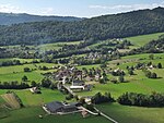
The Guiers Vif (French pronunciation: [ɡje vif], literally live Guiers) is a river in Auvergne-Rhône-Alpes in eastern France. It is located in the Regional Natural Park of Chartreuse, on the border between the municipalities of Saint-Pierre-d'Entremont (Isère) and Saint-Pierre-d'Entremont (Savoie). Its source is in the Cirque de Saint-Même. It flows towards the northwest. For most of its course, the river forms the border between the departments of Isère and Savoie. Near the communes of Entre-deux-Guiers and Les Echelles, it ends after 16.9 km (10.5 mi) as a right tributary of the Guiers.
Excerpt from the Wikipedia article Guiers Vif (License: CC BY-SA 3.0, Authors, Images).Guiers Vif
Rue des Charmettes, Chambéry
Geographical coordinates (GPS) Address Nearby Places Show on map
Geographical coordinates (GPS)
| Latitude | Longitude |
|---|---|
| N 45.4368 ° | E 5.7404 ° |
Address
Rue des Charmettes
Rue des Charmettes
73360 Chambéry
Auvergne-Rhône-Alpes, France
Open on Google Maps


