Morongo Basin
All accuracy disputesEndorheic basins of the United StatesGeography of San Bernardino County, CaliforniaInland EmpireMojave Desert ... and 6 more
Regions of CaliforniaSand to Snow National MonumentTwentynine Palms, CaliforniaValleys of San Bernardino County, CaliforniaValleys of the Mojave DesertYucca Valley, California

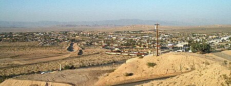
The Morongo Basin is an endorheic basin and valley region located in eastern San Bernardino County, in Southern California. The Morongo basin is part of the Inland Empire region, and is considered to be the easternmost portion of the Greater Los Angeles Area, the 2nd largest metropolitan region in the United States.
Excerpt from the Wikipedia article Morongo Basin (License: CC BY-SA 3.0, Authors, Images).Morongo Basin
Cottonwood Drive,
Geographical coordinates (GPS) Address Nearby Places Show on map
Geographical coordinates (GPS)
| Latitude | Longitude |
|---|---|
| N 34.13 ° | E -116.27 ° |
Address
Cottonwood Drive
Cottonwood Drive
92277
California, United States
Open on Google Maps


