place

Joshua Tree National Park
1936 establishments in CaliforniaArchaeological sites in CaliforniaClimbing areas of CaliforniaIUCN Category IIJoshua Tree National Park
National parks in CaliforniaNatural history of San Bernardino County, CaliforniaParks in Riverside County, CaliforniaParks in San Bernardino County, CaliforniaParks in Southern CaliforniaProtected areas established in 1936Protected areas established in 1994Protected areas of the Colorado DesertProtected areas of the Mojave DesertUse American English from February 2021Use mdy dates from February 2021
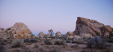
Joshua Tree Cyclops + Potato Head Sunrise

Joshua Tree National Park is an American national park in southeastern California, east of San Bernardino and Los Angeles and north of Palm Springs. It is named after the Joshua trees (Yucca brevifolia) native to the Mojave Desert. Originally declared a national monument in 1936, Joshua Tree was redesignated as a national park in 1994 when the U.S. Congress passed the California Desert Protection Act. Encompassing a total of 795,156 acres (1,242.4 sq mi; 3,217.9 km2) – slightly larger than the state of Rhode Island – the park includes 429,690 acres (671.4 sq mi; 1,738.9 km2) of designated wilderness. Straddling San Bernardino and Riverside Counties, the park includes parts of two deserts, each an ecosystem whose characteristics are determined primarily by elevation: the higher Mojave Desert and the lower Colorado Desert. The Little San Bernardino Mountains traverse the southwest edge of the park.

Excerpt from the Wikipedia article Joshua Tree National Park (License: CC BY-SA 3.0, Authors, Images).

Joshua Tree National Park
Cholla Trail,

Geographical coordinates (GPS) Address Nearby Places
placeShow on map

Wikipedia: Joshua Tree National ParkContinue reading on Wikipedia

Geographical coordinates (GPS)

Latitude Longitude
N 34.1 ° E -116.27 °
placeShow on map

Address

Cholla Trail 8382
92252
California, United States
mapOpen on Google Maps

Joshua Tree Cyclops + Potato Head Sunrise
Share experience

Nearby Places

Keys Desert Queen Ranch

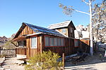
The Keys Ranch is the prime example of early settlement in the Joshua Tree National Park area. Bill Keys was the area's leading character, and his ranch is a symbol of the resourcefulness of early settlers. The ranch is an extensive complex of small frame buildings built between 1910 and Keys' death in 1964. Keys pursued both ranching and mining to make a living in the desert.William F. Keys was born at Palisade, Nebraska, in 1879. After working as a ranch hand and smelter worker, he was a deputy sheriff in Mohave County, Arizona. During a time in Death Valley, he befriended Death Valley Scotty, becoming involved in a swindle that resulted in the so-called "Battle of Wingate Pass". He arrived in the Twentynine Palms, California area in 1910. In the area that became Joshua Tree National Park, he became acquainted with local outlaw and cattle rustler Jim McHaney, taking care of him in declining health. Keys eventually took over McHaney's properties after McHaney's death, gradually expanding what became the Desert Queen, its name borrowed from the nearby Desert Queen Mine.Keys married Francis M. Lawton in 1918, and they had seven children together, three of whom died and were buried at the ranch. During a dispute over the Wall Street Mill, Keys shot and killed Worth Bagley. Keys was convicted of murder and went to San Quentin Prison, where Keys educated himself in the library. Keys was paroled in 1950 and was pardoned in 1956 through the efforts of Erle Stanley Gardner, author of the Perry Mason novels.Mining equipment at the ranch includes an arrastra and a stamp mill for ore processing. Other buildings include an adobe barn, a schoolhouse, a tack shed, machine shed, cemetery and a variety of houses and cabins. Park rangers provide guided walking tours of the ranch from October through May. Tours are limited in size and should be booked in advance.