place

Furnace Run (Catawissa Creek tributary)

Rivers of Columbia County, PennsylvaniaRivers of PennsylvaniaTributaries of Catawissa Creek
Mouth of Furnace Run

Furnace Run is a tributary of Catawissa Creek in Columbia County, Pennsylvania, in the United States. It is approximately 2.5 miles (4.0 km) long and flows through Catawissa Township and Main Township. The stream is the last named tributary to enter Catawissa Creek before its mouth. The stream's watershed has an area of 2.82 square miles (7.3 km2). The main rock formations are the Pottsville Group and the Mauch Chunk Formation. The stream itself is considered to be a high quality coldwater fishery and Class A Wild Trout Waters.

Excerpt from the Wikipedia article Furnace Run (Catawissa Creek tributary) (License: CC BY-SA 3.0, Authors, Images).

Furnace Run (Catawissa Creek tributary)
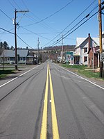
Fisher Run Road, Main Township

Geographical coordinates (GPS) Address Nearby Places
placeShow on map

Wikipedia: Furnace Run (Catawissa Creek tributary)Continue reading on Wikipedia

Geographical coordinates (GPS)

Latitude Longitude
N 40.96358 ° E -76.37335 °
placeShow on map

Address

Fisher Run Road 44
17815 Main Township
Pennsylvania, United States
mapOpen on Google Maps

Mouth of Furnace Run
Share experience

Nearby Places

Scotch Run (Catawissa Creek tributary)

Scotch Run is one of the main tributaries of Catawissa Creek in Columbia County, Pennsylvania, in the United States. It is approximately 7.8 miles (12.6 km) long and flows through Beaver Township and Main Township. The stream's watershed has an area of 9.10 square miles (23.6 km2). The stream is infertile and acidic. It is 7.2 feet (2.2 m) wide in its upper reaches and 17.0 feet (5.2 m) wide in its lower reaches. The main rock formations in the watershed include the Mauch Chunk Formation, the Pocono Formation, the Pottsville Formation, and the Spechty Kopf Formation. The main soils include Leck Kill soil and Hazleton soil. It flows between Nescopeck Mountain and McCauley Mountain. Nearly all of Scotch Run's length is within 1,640 feet (500 m) of a road. However, most of its length is not within 328 feet (100 m) of one. Part of Pennsylvania State Game Lands Number 58 is in the watershed and ephemeral natural pool system is located near the stream. The area in the vicinity of the stream was settled relatively late compared to the surrounding areas. The Pennsylvania Fish and Boat Commission carried out a survey of the creek in 1977. Scotch Run is designated as a Coldwater Fishery and a Migratory Fishery. In 1997, three species of fish were observed in the upper reaches of the stream, while eight species were observed in the lower reaches. Both reaches contained brown trout and brook trout. There is a hemlock-mixed hardwood palustrine forest along the stream.