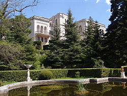
Kurpaty
Commons link is defined as the pagenameCrimea geography stubsRural settlements in CrimeaSeaside resorts in RussiaSeaside resorts in Ukraine ... and 2 more
Urban-type settlements in CrimeaYalta Municipality

Kurpaty (Ukrainian: Курпати; Russian: Курпаты; Crimean Tatar: Kurpatı) is an urban-type settlement in the Yalta Municipality of the Autonomous Republic of Crimea, a territory recognized by a majority of countries as part of Ukraine and annexed by Russia as the Republic of Crimea.Kurpaty is located on Crimea's southern shore at an elevation of 269 metres (883 ft). Nearby is the Dvuyakornaya Formation, containing several types of fossil. The settlement is located 8 km (5.0 mi) south west from Yalta. It is administratively subordinate to the Livadiya Settlement Council. Its population was 143 in the 2001 Ukrainian census. Current population: 136 (2014 Census).
Excerpt from the Wikipedia article Kurpaty (License: CC BY-SA 3.0, Authors, Images).Kurpaty
Царская тропа,
Geographical coordinates (GPS) Address Nearby Places Show on map
Geographical coordinates (GPS)
| Latitude | Longitude |
|---|---|
| N 44.444722222222 ° | E 34.126666666667 ° |
Address
Царская тропа
Царская тропа
98659
Republic of Crimea, Russia
Open on Google Maps


