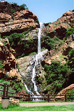
The Witwatersrand () (locally the Rand or, less commonly, the Reef) is a 56-kilometre-long (35 mi), north-facing scarp in South Africa. It consists of a hard, erosion-resistant quartzite metamorphic rock, over which several north-flowing rivers form waterfalls, which account for the name Witwatersrand, meaning "white water ridge" in Afrikaans. This east-west-running scarp can be traced with only one short gap, from Bedfordview (about 10 km [6 mi] west of O.R. Tambo International Airport) in the east, through Johannesburg and Roodepoort, to Krugersdorp in the west (see the diagram at left below).The scarp forms the northern edge of a 7-to-10-kilometre-wide (4–6 mi) plateau (or ridge) which rises about 200 m (660 ft) above the surrounding plains of the Highveld. A number of picturesque Johannesburg suburbs, including Observatory, Linksfield Ridge and Upper Houghton are located along the scarp, overlooking the rest of northern Johannesburg with views up to the Magaliesburg (although locals refer to segments of the scarp using area-specific names, such as Linksfield Ridge, Parktown Ridge or Observatory Ridge). The entire plateau-like structure is also often called the Witwatersrand. The plateau's elevation above sea-level is between 1,700 and 1,800 metres (5,600–5,900 ft).
The Witwatersrand plateau forms a continental divide, with the run-off to the north draining into the Indian Ocean via the Crocodile and Limpopo rivers, while the run-off to the south drains via the Vaal into the Orange River and ultimately into the Atlantic Ocean.Because of the extraordinary quantities of gold that have been extracted from the Witwatersrand rocks, the South African currency was named the rand in 1961 upon the declaration of the republic.
Witwatersrand and the Rand are names for the conurbation that developed along the range, although the terms are falling into disuse and Witwatersrand was the "W" in PWV (Pretoria-Witwatersrand-Vereeniging), the initial name of Gauteng province. In this context, it has lent its name to institutions including the University of the Witwatersrand (Wits University) and the defunct Rand Afrikaans University (RAU, now part of the University of Johannesburg), and to towns and regions such as the East Rand, West Rand and Randburg.


