place

Carluke railway station

1842 establishments in ScotlandCarlukeFormer Caledonian Railway stationsPages with no open date in Infobox stationRailway stations in Great Britain opened in 1842
Railway stations in South LanarkshireRailway stations served by ScotRailSPT railway stationsUse British English from March 2017
Carluke lanarkshire
Carluke lanarkshire

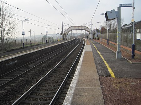
Carluke railway station is a railway station on the West Coast Main Line (WCML) that serves the town of Carluke, South Lanarkshire, Scotland. The station is managed by ScotRail and is predominantly served by Argyle Line commuter trains running between Lanark and Glasgow Central. The station lies at the western edge of the town, and enjoys panoramic views of the Clyde Valley and beyond to the hills of Lanarkshire and Ayrshire.

Excerpt from the Wikipedia article Carluke railway station (License: CC BY-SA 3.0, Authors, Images).

Carluke railway station
Station Road,

Geographical coordinates (GPS) Address External links Nearby Places
placeShow on map

Wikipedia: Carluke railway stationContinue reading on Wikipedia

Geographical coordinates (GPS)

Latitude Longitude
N 55.73115 ° E -3.8489 °
placeShow on map

Address

Carluke

Station Road
ML8 5AD
Scotland, United Kingdom
mapOpen on Google Maps

linkWikiData (Q1961509)
linkOpenStreetMap (10288496)

Carluke lanarkshire
Carluke lanarkshire
Share experience

Nearby Places

A73 road
A73 road

The A73 is a former trunk route in Scotland, that connects the M74 at Abington, Jct. 13 to the M80 motorway at Cumbernauld. Running for approximately 37 miles (60 km), it passes through the towns of Lanark, Carluke, Newmains, Chapelhall and Airdrie. Formerly a main route connecting the north of Scotland to England it has less importance these days, and is now merely a local feeder to the two motorways with which it connects. The sections between Abington & Carluke and Cumbernauld & Newhouse were the first sections to be downgraded from a trunk route to a secondary route, following the construction of the shorter M73 further west, which connected the M74 at Jct. 4. This motorway removed the need for vehicles from the north to use the A73 to reach England. Following this downgrading, the remaining section of A73 between Carluke and Newhouse remained a trunk route for vehicles travelling between Glasgow and Peebles. For this reason, two new sections of dual carriageway were built between Bellside & Newmains and Bogside & Law, as well as a new bypass for the town centre of Carluke, where the trunk route continues as the A721. Eventually though, the M74 was completed and it became easier for vehicles travelling from Peebles to Glasgow, to use the A702 trunk route instead, which also joins the M74 at Abington. For this reason, the entire length of the A73 was downgraded to a secondary route, although it is still heavily trafficked, especially between Lanark and the M8 at Newhouse.

Edinburgh the Walk
Edinburgh the Walk

Edinburgh the Walk (stylized Edinburgh THE WALK), is a guidebook by Roddy McDougall and Elizabeth May. It describes a long-distance footpath linking the parks, green spaces and hills of Scotland's capital city. The book outlines a 69 kilometres (43 mi) long route which is divided into eight sections. While not currently waymarked, it follows parts of several long-established walking routes in the city - John Muir Way, Water of Leith Walkway, River Almond, Lothian Walkway as well as paths created from the city's former railway lines. It is intended to be for Edinburgh what the Capital Ring is for London - a walking route which leads through different parts of the city which might not otherwise be visited. The book highlights the geology, architecture and arts of Edinburgh beyond its better-known centre including some of those who have contributed to the city's history - novelist and poet Sir Walter Scott, geologist and writer Hugh Miller, geologist James Hutton and the Duke of Buccleuch. The route starts at Edinburgh Castle and heads north east towards the port of Leith before going alongside the southern shore of the Firth of Forth. From there it turns inland at Cramond and heads south over Corstorphine Hill towards Craiglockhart Hill.The route then takes in the summits of Braid Hills and Blackford Hill before heading towards Craigmillar Castle. It then leads north towards the seaside resort of Portobello, Edinburgh before climbing up to the city's highest point, the extinct volcano Arthur's Seat. The route ends at the gates to Holyrood Palace beside the Scottish Parliament Building. Travel-writer Richard Franks completed the whole walk in three and a half days. The route was also featured on 'Out of Doors' on BBC Radio Scotland in August 2022. Each section of the route begins and ends with access to public transport.