place

Papanui Inlet

Inlets of New ZealandLandforms of OtagoOtago Peninsula
Otago harbour landsat

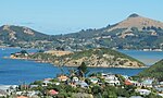
Papanui Inlet is the northernmost of two large inlets in the Pacific coast of Otago Peninsula, in the South Island of New Zealand. The inlet's name is of Māori origin, and means large plain (papa, flat land, and nui, big). The name originally referred to the area of dunes and mudflats immediately to the north of the inlet, but was transferred to the inlet itself at the time of European settlement on the peninsula. The inlet was also known by Māori as Makahoe.Like its near neighbour, Hoopers Inlet, Papanui Inlet is known for its diverse bird life. The inlet lies 3 km to the east of Portobello. A short road linking the two inlets enables Papanui Inlet to be reached by road from both Portobello and the city of Dunedin (of which it is administratively a part), the centre of which lies 18 kilometres to the west. Both inlets are shallow, becoming predominantly sand and mud flats at low tide. The mouth of Papanui Inlet opens to the east, directly into the Pacific Ocean. While the southern shore of the inlet is flanked by steep hills, the northern shore is dominated by a large area of flat land known as Okia Flat, much of which is protected as Okia Reserve. Beyond this lies Wickliffe Bay, which is bordered by Victory Beach, Otago Peninsula's longest beach. This flat land effectively narrows the mouth of the inlet. The remains of the 1861 wreck of the SS Victory (for which the beach is named) are still visible close to the inlet's mouth at low tide. Both this wreck and a historic midden close to the southern shore of the inlet's mouth are registered as Category II historic sites by the New Zealand Historic Places Trust.Papanui Inlet is separated from Hoopers Inlet by a strip of land which is the isthmus to a hilly peninsula containing Cape Saunders and the peninsula's highest point, the 408-metre Mount Charles. A road, leading to Cape Saunders, skirts the southern shore of the inlet. The inlet is registered as a Coastal Protection Area by the Otago Regional Council, due to its cultural and spiritual values to the Kai Tahu iwi, its status as an important habitat for bird and sea life, and for its historic sites.

Excerpt from the Wikipedia article Papanui Inlet (License: CC BY-SA 3.0, Authors, Images).

Geographical coordinates (GPS)

Latitude Longitude
N -45.847222222222 ° E 170.69444444444 °
placeShow on map

Address

Harwood


Otago, New Zealand
mapOpen on Google Maps

Otago harbour landsat
Share experience

Nearby Places

Hoopers Inlet
Hoopers Inlet

Hoopers Inlet is one of two large inlets in the Pacific coast of Otago Peninsula, in the South Island of New Zealand. The origin of the name is a little confused; there was an early settler family called Hooper who lived nearby, but the name appears on charts made prior to their arrival in the area. A. W. Reed has suggested that the name is a corruption of "Cooper's Inlet", named for Daniel Cooper, the ship's captain of the Unity, which operated in the area during the Peninsula's years as a base for sealers. The inlet was on a traditional Māori route for collecting shellfish, which ran from Otakou to what is now St. Clair. The Māori name for the inlet was Puke-tu-roto, meaning either "hills standing around a lake" or "hills standing inland".Like its near neighbour, Papanui Inlet, Hoopers Inlet is known for its diverse bird life. The inlet lies 2 km to the south of Portobello and can be reached by road from both there and the city of Dunedin (of which it is administratively a part), the centre of which lies 15 kilometres to the west. Both inlets are shallow, becoming predominantly sand and mud flats at low tide. The mouth of Hoopers Inlet is narrowed by a large spit, the seaward coast of which forms Allans Beach. Behind this beach is a significant area of wetland and swamp, which is home to many species of flora and birds.Hoopers Inlet is separated from Papanui Inlet by a strip of land which is the isthmus to a hilly peninsula containing Cape Saunders and the peninsula's highest point, the 408-metre Mount Charles.

Portobello, New Zealand

Portobello is a village beside the Otago Harbour halfway along the Otago Peninsula in Dunedin City, New Zealand. It lies at the foot of a small peninsula (Portobello Peninsula) between Portobello Bay and Latham Bay. Like scores of Dunedin features, Portobello was named after a locality in Edinburgh, Scotland, also called Portobello. At the end of Portobello Peninsula sits a marine research station, the Portobello Marine Laboratory, which is part of the University of Otago. Close to the end of this peninsula lies Quarantine Island / Kamau Taurua. Portobello features a Historical Society Museum, the 1908 Restaurant, a local primary school (Portobello School, Years 1-8), the old Portobello Hotel (a pub), a cafe and several accommodation providers, including a camping ground, bed and breakfasts and motels. A local dairy acts as the community's grocers, though most of the village's retail needs are served by Dunedin, which is easily accessed via the winding but well-surfaced Portobello Road which runs along the edge of the harbour. A multi-year project to raise and widen this road and add a 19km shared-use pathway is nearing completion, safely connecting Portobello to Dunedin for cyclists and walkers. This pathway is part of the larger Otago Harbour Cycleway. A more convoluted but scenic route, Highcliff Road, connects Portobello with Dunedin city centre via the ridge of the peninsula. Boating is an historical focus for Portobello. In the past, Portobello residents caught the ferry to the city, before the Portobello Road along the foreshore was constructed. Today, scheduled ferry service to Kamau Taurua and Port Chalmers departs from the recently renovated ferry jetty, a short distance from the centre of the village. A boating club maintains a slipway and boat shed near the jetty. Portobello Community Inc. is the local community group, which works to improve Portobello for its community.