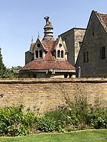
Little Linford

Little Linford is a village and former civil parish, now in the parish of Haversham-cum-Little Linford, in the City of Milton Keynes, Buckinghamshire, England. Located near the M1 motorway, the village is about 2 miles (3.2 km) north-west of Newport Pagnell and 3.5 miles (5.6 km) north of Central Milton Keynes. The village is separated from its neighbour and namesake Great Linford (and the rest of the Milton Keynes urban area) by the floodplain of the River Great Ouse. In 1931 the parish had a population of 45. On 1 April 1934 the parish was abolished and merged with Haversham to form "Haversham cum Little Linford".Little Linford was initially a hamlet in the manor and ecclesiastical parish of Linford. The parish church is dedicated to St Leonard. The traditional parish name 'Linford' is an Old English language word that means 'ford where maple trees grow'. In the Domesday Book of 1086 the village was recorded as Linforde. The prefix 'Little' was added to distinguish it from Great Linford.
Excerpt from the Wikipedia article Little Linford (License: CC BY-SA 3.0, Authors, Images).Little Linford
Little Linford Lane,
Geographical coordinates (GPS) Address Nearby Places Show on map
Geographical coordinates (GPS)
| Latitude | Longitude |
|---|---|
| N 52.091 ° | E -0.772 ° |
Address
Little Linford Lane
Little Linford Lane
MK19 7EA , Haversham-cum-Little Linford
England, United Kingdom
Open on Google Maps


