place

South Baltimore, Baltimore

Baltimore geography stubsNeighborhoods in BaltimoreSouth Baltimore, Baltimore
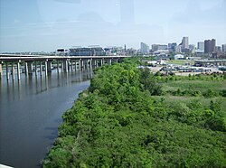
2016 07 27 08 30 29 View north along Maryland State Route 2 (Hanover Street) between Wells Street and Barney Street in Baltimore City, Maryland

South Baltimore is a neighborhood in the Southern District of Baltimore, located to the west of the neighborhood of Riverside and south of Federal Hill. Its boundaries are marked by East Ostend Street (north), Light Street (east), Race Street (west) and Interstate 95 (south).

Excerpt from the Wikipedia article South Baltimore, Baltimore (License: CC BY-SA 3.0, Authors, Images).

South Baltimore, Baltimore
South Charles Street, Baltimore South Baltimore

Geographical coordinates (GPS) Address Nearby Places
placeShow on map

Wikipedia: South Baltimore, BaltimoreContinue reading on Wikipedia

Geographical coordinates (GPS)

Latitude Longitude
N 39.2705 ° E -76.6137 °
placeShow on map

Address

Heath Street City Farm (Heath Street Park)

South Charles Street 1701
21230 Baltimore, South Baltimore
Maryland, United States
mapOpen on Google Maps

2016 07 27 08 30 29 View north along Maryland State Route 2 (Hanover Street) between Wells Street and Barney Street in Baltimore City, Maryland
Share experience

Nearby Places

Riverside Park (Baltimore)

Riverside Park is a nearly 17-acre (6.9 ha) public park located in the historic Riverside neighborhood in Baltimore, Maryland. Early in Baltimore history, the site of Riverside Park was often used as a lookout point because of the clear view it offered of the South Baltimore peninsula and the Patapsco River. Because of this, during the War of 1812 Major General Samuel Smith ordered Captain Samuel Babcock to build a circular battery at the location, called Fort Lookout. Commanded by Lt. George Budd during the Battle of Baltimore, the battery played a key role in the defense of Baltimore. Combined with the garrisons at Forts Covington and Babcock, the forces at Fort Lookout assisted in repelling a British attempt to assault the peninsula by land, saving the city. After the battle, the fort was renamed Fort Wood in honor of Colonel Eleazer Wood, and the site remained in limited use through the mid-1800s.In 1854, Baltimore applied to condemn 3 acres for public use along Randall, Covington and Heath Streets and rename the property Battery Square. The city formally acquired the 3-acre square in 1862 from James Polk. In 1873, the city acquired an additional 14 acres to the south of Battery Square and renamed the property Riverside Park, making it one of the oldest parks in the city system. In 1876, the city passed an ordinance putting the park under control of the Public Park Commission.During the Baltimore Railroad Riots of 1877, the park served as an encampment for the 5th Regiment of the Maryland National Guard. After assisting with the riots downtown, the regiment marched to Riverside Park on July 30 to help guard the South Baltimore rail lines. On August 1, the regiment put on an exhibition for the local residents.In the following years, the Public Park Commission made several improvements to the park: a large marble fountain in the center, a nursery, iron railings, and gas lighting. Large attendances (in the thousands) were not unknown in the late 1800s. A swimming pool, playgrounds, and sports fields and courts were added at various times during the 20th century. Concerts and events at the gazebo, which are held to this day, were a popular attraction for the local citizens and provided a welcome distraction for the immigrant community that sprouted around the park.Baltimore City Rec and Parks announced in 2019 that it has developed plans for athletic field improvements and a fieldhouse renovation at Riverside Park. Overall, field improvements will consist of new lights, backstops, dugouts, fencing, basketball court, field drainage, and grass. The fields will be reconfigured to incorporate the CSX property that the city acquired along Wells street. Plans have been developed for the fieldhouse to renovate the bathrooms, storage areas, concession area, and seating.

Leadenhall Street Baptist Church

Leadenhall Street Baptist Church is a historic Baptist church located at Baltimore, Maryland, United States. It is a gable-front rectangular brick temple with simple Renaissance Revival detail. The original exterior wall surfaces have been covered with formstone on the main façade and stucco elsewhere. It features round-arched stained glass windows on each side bay. It was built in 1873, by Joseph Thomas & Son for the city's African American Baptists who were then centered in the old southwest area from the downtown business district of Baltimore in the "Sharp-Leadenhall" (named for the intersecting nearby streets) community in the old "South Baltimore" area. Nearby is its now famed revitalized "Inner Harbor" area of the old "Basin" for the harbor port. The neighborhood is just west of the Federal Hill community and commercial district connected by West Hamburg Street, which is along South Charles and Light Streets, and the famous hill itself, which was the site of a celebratory picnic in 1788 after a parade of the various guilds, organizations and military units of old "Baltimore Town" to commemorate the ratification by Maryland of the new Federal Constitution, and later fortified with earthen embankments and large cannons of artillery by Northern troops of the Union Army a month after, during the Civil War to keep a close watch on and control on the Southern-sympathizing citizens of the City who had erupted in April 1861, in a riot attacking passing Massachusetts and Pennsylvania troops from the President Street Station on the east side from Philadelphia and the North, on their way to the nearby (a few blocks away with the Washington tracks running right by the Church) Camden Street Station of the famous Baltimore and Ohio Railroad to defend the National Capital of Washington from the newly seceded Virginians and Confederates. The "Sharp-Leadenhall" neighborhood just west of the Harbor was one of the first neighborhoods to become predominantly African American residents among the City's largest free-Black population in America, in the late 19th century. Prior to this era of beginning housing segregation, most of Baltimore's "free citizens of color" lived amidst the white population in the small compact town, residing on the smaller streets and alleyways in between larger avenues and main streets, seeking employment in the homes and businesses of the majority white population. Often poorer residents, lived right in back or around the corner from substantial mansions and townhouses of the wealthy and well-to-do. In later years, additional populations of free blacks began moving to the northwest just beyond the Mount Vernon-Belvedere neighborhood and beyond Seton Hill, along the future Pennsylvania Avenue and Druid Hill Avenue of what became known as Upton. The building was built and financed by the predominantly "colored" Maryland Baptist Union Association, (as opposed to the organization of the Baptist Convention of Maryland) who had generally separated from the white Baptists after often worshipping together in the small building during the colonial days of the late 18th century (although most of the time in upper balconies or separate pews/chairs in the sanctuary), into the early 19th century of the American Republic. It is the second oldest Black church edifice in Baltimore, and home to one of the city's largest African American congregations. Another prominent congregation in the area that was an important force in the City's burgeoning African-American community was the nearby Sharp Street Methodist Church which later followed its members in later decades also to the northwest neighborhoods, where after a series of National Methodist church mergers is now still called Sharp Street United Methodist Church, although it left that location long ago, unlike the Leadenhall Church. Leadenhall Street Baptist Church was listed on the National Register of Historic Places in 1979. which is maintained by the National Park Service of the United States Department of the Interior, according to the Historic Sites Act of August 1935. With the designation of much of downtown Baltimore and its immediate inner eastern, western and northern residential historic neighborhoods as the Baltimore City National Heritage Area has been established. Under the same NPS and USDI influence and direction, with local supervision from city and state historical professionals, a series of new additional huge plaques have been mounted on streetside poles with illustrations, maps and text of the various historic sites, buildings, monuments and various tours of the heritage areas in the immediate block of that particular sign. On the other side is similar material for the BCNHA in general, and exhibits/tours available to be led and run out of the Visitors Center pavilion, along the western shore of the "Inner Harbor", with the additional printed brochures containing maps, pictures and text plus the material available on an internet website. Prominent display is given to the African-American heritage in the southwest "Sharp-Leadenhall" and northwest "Upton/Druid Hill" areas by the Pennsylvania Avenue commercial and entertainment/social district. It points out the Leadenhall Church site and many other black churches and institutions with the homes and locations of significant people.