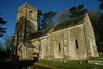
Syde
Cotswold DistrictUse British English from March 2015Villages in Gloucestershire

Syde, often in the past spelt Side, is a small village and civil parish in Gloucestershire, England. It lies in the Cotswolds, near the source of the River Frome, some six miles north west of Cirencester and seven miles east of Painswick. There is a Church of England parish church called St Mary's.The principal house is Syde Manor, a listed building which dates from the 16th and 17th centuries, built of stone rubble with a Cotswold stone roof and gables. Some of its mullioned windows have unusual three-centred arches at their heads. The front of the house which has the main entrance was added in the late 18th or early 19th century.
Excerpt from the Wikipedia article Syde (License: CC BY-SA 3.0, Authors, Images).Syde
Salt Way, Cotswold District Syde
Geographical coordinates (GPS) Address Nearby Places Show on map
Geographical coordinates (GPS)
| Latitude | Longitude |
|---|---|
| N 51.796 ° | E -2.075 ° |
Address
Salt Way
GL7 7JZ Cotswold District, Syde
England, United Kingdom
Open on Google Maps


