Kafr Qasim massacre

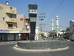
The Kafr Qasim massacre took place in the Israeli Arab village of Kafr Qasim situated on the Green Line, at that time, the de facto border between Israel and the Jordanian West Bank on October 29, 1956. It was carried out by the Israel Border Police (Magav), who killed Arab civilians returning from work during a curfew of which they were unaware, imposed earlier in the day on the eve of the Sinai War. In total 48 people died, of which 19 were men, 6 were women and 23 were children aged 8–17. Arab sources usually give the death toll as 49, as they include the unborn child of one of the women.The border policemen who were involved in the shooting were brought to trial and found guilty and sentenced to prison terms ranging from 7 to 17 years. The brigade commander was sentenced to pay the symbolic fine of 10 prutot (old Israeli cents). The Israeli court found that the command to kill civilians was "blatantly illegal". However, all of the sentences were later reduced, with some of those convicted receiving presidential pardons. All of those convicted were released no later than November 1959.One of those convicted, Gabriel Dahan, was later placed in charge of "Arab Affairs" by the city of Ramla.Issachar (Yissachar) "Yiska" Shadmi—the highest-ranking official prosecuted for the massacre—stated, shortly before his death, that he believed that his trial was staged to protect members of the Israeli political and military elite, including Prime Minister David Ben Gurion, from taking responsibility for the massacre. The purpose was to portray the perpetrators as a group of rogue soldiers, rather than people acting under higher orders.In December 2007, President of Israel Shimon Peres formally apologised for the massacre. In October 2021, a Joint List bill to have the massacre officially recognized was turned down in the Knesset.
Excerpt from the Wikipedia article Kafr Qasim massacre (License: CC BY-SA 3.0, Authors, Images).Kafr Qasim massacre
Haled Ibn AlWalid,
Geographical coordinates (GPS) Address Nearby Places Show on map
Geographical coordinates (GPS)
| Latitude | Longitude |
|---|---|
| N 32.114166666667 ° | E 34.971388888889 ° |
Address
ח'אלד אבן אל וליד
Haled Ibn AlWalid
4809284
Center District, Israel
Open on Google Maps


