place

Kafr Qasim

Arab localities in IsraelCentral District (Israel)Cities in Central District (Israel)Cities in IsraelTriangle (Israel)
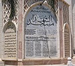
Kafr Quasim Memorial, Israel

Kafr Qasim (Arabic: كفر قاسم, Hebrew: כַּפְר קָאסִם), also spelled as Kafr Qassem, Kufur Kassem, Kfar Kassem and Kafar Kassem, is a hill-top city in Israel with an Arab population. It is located about 20 km (12 mi) east of Tel Aviv, on the Israeli side of the Green Line separating Israel and the West Bank, in the southern portion of the "Little Triangle" of Arab-Israeli towns and villages. In 2021 its population was 24,757. The town was the site of the Kafr Qasim massacre, in which the Israel Border Police killed 49 civilians on October 29, 1956. On February 12, 2008, Israeli Minister of the Interior Meir Sheetrit declared Kafr Qasim a city in a ceremony held at the town.

Excerpt from the Wikipedia article Kafr Qasim (License: CC BY-SA 3.0, Authors, Images).

Geographical coordinates (GPS)

Latitude Longitude
N 32.1151 ° E 34.9751 °
placeShow on map

Address

א שוהדא

A Shuhada
4809284
Center District, Israel
mapOpen on Google Maps

Kafr Quasim Memorial, Israel
Share experience

Nearby Places

Kafr Qasim massacre
Kafr Qasim massacre

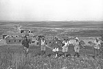
The Kafr Qasim massacre took place in the Israeli Arab village of Kafr Qasim situated on the Green Line, at that time, the de facto border between Israel and the Jordanian West Bank on October 29, 1956. It was carried out by the Israel Border Police (Magav), who killed Arab civilians returning from work during a curfew of which they were unaware, imposed earlier in the day on the eve of the Sinai War. In total 48 people died, of which 19 were men, 6 were women and 23 were children aged 8–17. Arab sources usually give the death toll as 49, as they include the unborn child of one of the women.The border policemen who were involved in the shooting were brought to trial and found guilty and sentenced to prison terms ranging from 7 to 17 years. The brigade commander was sentenced to pay the symbolic fine of 10 prutot (old Israeli cents). The Israeli court found that the command to kill civilians was "blatantly illegal". However, all of the sentences were later reduced, with some of those convicted receiving presidential pardons. All of those convicted were released no later than November 1959.One of those convicted, Gabriel Dahan, was later placed in charge of "Arab Affairs" by the city of Ramla.Issachar (Yissachar) "Yiska" Shadmi—the highest-ranking official prosecuted for the massacre—stated, shortly before his death, that he believed that his trial was staged to protect members of the Israeli political and military elite, including Prime Minister David Ben Gurion, from taking responsibility for the massacre. The purpose was to portray the perpetrators as a group of rogue soldiers, rather than people acting under higher orders.In December 2007, President of Israel Shimon Peres formally apologised for the massacre. In October 2021, a Joint List bill to have the massacre officially recognized was turned down in the Knesset.

Highway 5 (Israel–Palestine)

Highway 5 or the Trans-Samaria Highway (Hebrew: כביש חוצה שומרון, Kvish Hotze Shomron), is one of Israel's main highways, connecting the Mediterranean coast immediately north of Tel Aviv with the central Sharon plain and eastwards to Ariel and other Israeli settlements in the northern West Bank. The name Highway 5 is commonly used to describe the section of the highway running from the road's western end at the Glilot Interchange until it reaches the main entrance of Ariel. In this capacity it intersects and creates a connection between four important arterial freeways in the northern Tel Aviv area: The Coastal Highway (Highway 2), the Ayalon Highway (Highway 20), Geha Highway (Highway 4) and the Cross-Israel Highway (Highway 6).An alternate name for the entire highway is Kvish Hotze Shomron meaning the Cross-Samaria highway though often this name is used when referring specifically to the section of the road in the West Bank, i.e., past the Green Line, where it continues east towards the Jordan Valley in the West Bank. This section from the Green Line to its eastern end has also been dedicated as "Derekh Haim" (Haim's Road, but also "Way of Life") after the late Haim Landau, a former Israeli Minister of Transportation. Highway 5 initially reached Rosh HaAyin located inside of the green line, and served mainly the densely populated Gush Dan metropolitan area. In the West Bank, the main road was still the old Road 505, which since the events of the Second Intifada in 2000 has been partially closed to Jewish transportation. In the beginning of the 1990s, with the growth of Ariel and the settlements around it, arose the need for a more modern and wider road, than the single-lane low-quality Road 505. Therefore, Highway 5 was extended some 20 km to the east of the Green Line, ending almost within sight of Ariel and serving the largest block of the Israeli settlements in the northern West Bank counting about 50,000 people, as well as the Barkan Industrial Park. At the time, this section of Highway 5 was one of the biggest infrastructure projects that Israel had undertaken in the West Bank. As of 2017 the road terminates at a roundabout at the Ariel junction where it merges into Road 505 which continues east past Ariel until Petza'el, which is located on Route 90, the north–south road parallel to the Israel-Jordan border in the Jordan Valley. The western section of the highway consists of between 3 and 5 lanes in each direction, which reduces in number as the highway heads eastward. The westward section surrounding Gush Dan is as of 2017 one of the most congested in Israel.Highway 531, is a freeway which parallels Highway 5 and runs approximately 5–6 km to the north, was opened in 2017, and also contains a rail system. A toll fast lane project is planned along Highway 5.