RCAF Station Guelph

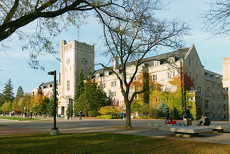
RCAF Station Guelph was a Second World War British Commonwealth Air Training Plan (BCATP) station located in Guelph, Ontario on the campus of the Ontario Agricultural College (OAC), the Ontario Veterinary College (OVC), and the Macdonald Institute. The station is usually known as No. 4 Wireless School and was home to several schools as well as test facilities for air force kitchens. The relationship between the Royal Canadian Air Force and the OAC began in January 1940 when the air force began to send airmen to the OAC to be trained as chefs. This instruction was provided on a contract basis and the OAC remained under the control of the Province of Ontario. In May 1941 the RCAF took control of a large portion of the campus, and by July 1941 a standard RCAF air station was operating there with headquarters in Johnston Hall. The largest school was the Wireless School, which trained airmen to be Wireless Operators. Many moved on to Bombing and Gunnery School to qualify as Wireless Air Gunners. These airmen served as aircrew on large Commonwealth aircraft. Wireless Air Gunners served RAF Bomber Command, perhaps in No. 6 Group RCAF, RAF Coastal Command, and RAF Ferry Command. Those posted to Home Defence in Canada went to RCAF Eastern Air Command or RCAF Western Air Command. This list is not exhaustive. Some airwomen were trained to be Wireless Operator, Ground. The second largest school was the School of Cookery, which trained airmen and airwomen to be chefs in air stations. The British Commonwealth Air Training Plan was a temporary wartime measure scheduled to end on 29 March 1945. In March 1944, Air Minister Power announced that No. 4 Wireless School would close on 29 December 1944. The school actually closed on 12 January 1945, when an air force transition team took over, and on 22 February 1945 the RCAF formally withdrew and returned the campus to the OAC. At least 8,000 airmen and airwomen were trained at RCAF Station Guelph.
Excerpt from the Wikipedia article RCAF Station Guelph (License: CC BY-SA 3.0, Authors, Images).RCAF Station Guelph
Winegard Walk, Guelph
Geographical coordinates (GPS) Address Nearby Places Show on map
Geographical coordinates (GPS)
| Latitude | Longitude |
|---|---|
| N 43.5325 ° | E -80.229166666667 ° |
Address
Winegard Walk
N1G 1Y1 Guelph
Ontario, Canada
Open on Google Maps


