place

Nasketucket Bay State Reservation

1999 establishments in MassachusettsMattapoisett, MassachusettsParks in Plymouth County, MassachusettsProtected areas established in 1999State parks of Massachusetts
Use mdy dates from August 2023

Nasketucket Bay State Reservation, managed by the Massachusetts Department of Conservation and Recreation, is located in Mattapoisett, Massachusetts, along the coastline of southeast Massachusetts. The park includes 210 acres (85 ha) of rocky shoreline open field and wooded trails. A parking lot is located at the northeast corner of the reservation. The reservation is accessed by Route 6, to Brandt Island Road to Brandt Beach Road. A parking lot is located at the northeast corner of the reservation and a trail leads circuitously south to the rocky beach at the bay. Before becoming a reservation, the land was going to be developed into house lots. The main trail loosely follows the original property owner’s driveway, and was cleared by the developers. The clearings intended for some of the houses are still visible. Nature has taken hold since, and now presents some very nice walking trails. Off-road vehicles are not permitted.

Excerpt from the Wikipedia article Nasketucket Bay State Reservation (License: CC BY-SA 3.0, Authors).

Nasketucket Bay State Reservation
Mattapoisett Neck Road,

Geographical coordinates (GPS) Address Website External links Nearby Places
placeShow on map

Wikipedia: Nasketucket Bay State ReservationContinue reading on Wikipedia

Geographical coordinates (GPS)

Latitude Longitude
N 41.635333333333 ° E -70.836972222222 °
placeShow on map

Address

Nasketucket Bay State Reservation

Mattapoisett Neck Road
02739
Massachusetts, United States
mapOpen on Google Maps

Website
mass.gov

linkVisit website

linkWikiData (Q15261071)
linkOpenStreetMap (16916251)

Share experience

Nearby Places

Ned Point Light
Ned Point Light

Ned Point Light is a historic lighthouse on Ned's Point Road in Mattapoisett, Massachusetts. The lighthouse was built in 1838 at a cost of approximately $5,000, and named after Ned Dexter, a local farmer. Under the supervision of a local builder, Leonard Hammond, the lighthouse was constructed with a birdcage-style lantern similar to Bird Island Light found in Marion, Massachusetts. The stone used for the lighthouse was all locally sourced, with most of it originating from nearby beaches. Inside, there are 32 granite steps that are cantilevered to the outside wall without the use of mortar. The original lantern used 11 whale oil lamps, each with its own parabolic reflector. The lamps and reflectors were replaced by a fifth order Fresnel lens in 1857, along with a change to an octagonal lantern. The Great Blizzard of 1888 significantly damaged the keeper's stone house, resulting in it being demolished and the building of a wooden replacement. Following the lighthouse's automation in 1923, the keeper's house became unnecessary. The original stone keeper's house was loaded on a barge and taken to Wing's Neck Light in Bourne, Massachusetts. The lighthouse was deactivated from 1952, but remained under control of the US Coast Guard. Following modernization in 1961, the lighthouse was reactivated in 1961 with its current 6-second isophase. The lighthouse was added to the National Register of Historic Places in 1982, and approved in 1988.

Unitarian Memorial Church

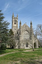
Unitarian Memorial Church is a historic church on 102 Green Street in Fairhaven, Massachusetts, home to the Unitarian Universalist Society of Fairhaven. The congregation was founded in 1819, moved into the Washington Street Christian Meetinghouse in 1832, and called its first minister in 1840. The Reverend Jordinn Nelson Long is its currently serving minister, and the Society President is Lawrence DeSalvatore. UUSF is a member congregation of the Boston-based Unitarian Universalist Association, and a designated GLBTQA Welcoming Congregation, a UUA Honor Congregation, and a part of the Green Sanctuary movement. Services are held in the neo-Gothic sanctuary at 10:30 a.m. from September through mid-June each year. The church was added to the National Register of Historic Places in 1996. The Unitarian Memorial Church in Fairhaven was built, financed and donated to the Unitarians in 1904 by Henry H. Rogers in memory of his mother, Mary Eldredge Huttleston. The church was designed by Boston architect Charles Brigham in a Gothic Revival style. It is one hundred fourteen feet (34.75m) in height, one hundred feet (30.48m) long in body and fifty-three feet (16.15m) wide. The nave is thirty-two feet (9.75m) wide and seventy-one feet (21.64m) long. The main aisle is sixty-two feet (18.90m) long and six feet (1.83m) wide. The church, parish house and former parsonage (now Harrop Center) of the Unitarian Society are so placed as to form three sides of a quadrangle, set among well-kept lawns and shrubbery. Granite (locally quarried) with Indiana limestone decorative carvings dominate the exterior while marble and limestone carvings dominate the interior. All stonework artistry was created by forty-five Italian craftsmen brought to Fairhaven by Rogers.