place

Mynydd Eglwysilan

Mountains and hills of Caerphilly County Borough

Mynydd Eglwysilan is a 355-metre-high hill in the Caerphilly county borough in South Wales 3 km to the south of Nelson and a similar distance southwest of Ystrad Mynach. To its south is Senghenydd at the head of the Aber Valley. Like neighbouring Cefn Eglwysilan, the hill is named after the hamlet of Eglwysilan 4 km to the southwest, the church here being dedicated to an obscure Saint Ilan. Remains of a linear earthwork known as Senghenydd Dyke stretch across the southern side of the hill. It is considered to mark the edge of an extensive 13th-century deer park associated with nearby Caerphilly Castle.

Excerpt from the Wikipedia article Mynydd Eglwysilan (License: CC BY-SA 3.0, Authors).

Mynydd Eglwysilan
Bwlch Carnygelli,

Geographical coordinates (GPS) Address Nearby Places
placeShow on map

Wikipedia: Mynydd EglwysilanContinue reading on Wikipedia

Geographical coordinates (GPS)

Latitude Longitude
N 51.6254 ° E -3.2676 °
placeShow on map

Address

Bwlch Carnygelli

Bwlch Carnygelli
CF46 6PL , Gelligaer
Wales, United Kingdom
mapOpen on Google Maps

Share experience

Nearby Places

Llanvabon

Llanvabon (also known as Llanfabon) is an area and former parish in South Wales. As described in 1849, it comprised two hamlets, in the union of Merthyr Tydfil, hundred of Caerphilly, county of Glamorgan, 9 miles (S. S. E.) from Merthyr Tydfil; containing 1449 inhabitants. A Topographical Dictionary of Wales (1849) described it as follows: This parish is bounded on the west by the river Tâf, and on the east by the Romney; and comprises about 5000 acres, of which 1120 are arable, 2230 pasture, 1000 common, 500 woodland consisting chiefly of oak, and the remainder roads and water. The surface is in general mountainous; and the scenery picturesque, especially in the vicinity of the village of Craigyberthlwyd, from which the views are striking and beautiful. The soil comprehends gravel, clay, and peat, and the chief agricultural produce is wheat, barley, and oats, the last of which is grown in a larger quantity than either of the two former. Tiles for building are made, and there are excellent stone-quarries, and coal-mines, but they are not in operation to any great extent, the latter being chiefly on the border, and appropriated to the use of the neighbourhood only. The greater part of the colliers of Gellygaer, an adjoining parish, live in Llanvabon. The ancient seat of the Lanbradach family is situated here; and besides the village above-named, the parish contains those of Quakers'-Yard and Nelson. It is intersected by the road from Cardiff to Merthyr, which passes about two miles and a half westward from the church; and by the Glamorganshire canal, on the banks of which, within its limits, is situated the Navigation-House, where this important line of communication is joined by the Aberdare Canal, and where barges are loaded with coal and iron for the port of Cardiff. The TâfVale railway, also, passes by Quakers'-Yard and the Navigation-House, and is joined in this vicinity by the Aberdare railway, for the construction of which an act was obtained in 1846. The living is consolidated with the vicarage of Eglwysilan: the tithes have been commuted for £270, of which a sum of £200 is payable to the Dean and Chapter of Llandaf, and £70 to the vicar. The church, dedicated to St. Mabon, is an ancient structure, consisting of a nave and chancel, forty-three feet in length and twentyone in breadth, and containing accommodation for about 120 persons. There are two places of worship for Calvinistic Methodists, two for Independents, and one for Baptists; in each of which a Sunday school is also held. James Thomas, in 1730, gave by will a rent-charge of £2 for the benefit of the poor, to be equally divided between those of each hamlet. The area is now part of the current parish of Nelson, and part of the borough of Caerphilly. The population of Nelson is 4,647 though a figure for Llanvabon is not available.
Senghenydd colliery disaster

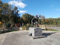
The Senghenydd colliery disaster, also known as the Senghenydd explosion (Welsh: Tanchwa Senghennydd), occurred at the Universal Colliery in Senghenydd, near Caerphilly, Glamorgan, Wales, on 14 October 1913. The explosion, which killed 439 miners and a rescuer, is the worst mining accident in the United Kingdom. Universal Colliery, on the South Wales Coalfield, extracted steam coal, which was much in demand. Some of the region's coal seams contained high quantities of firedamp, a highly explosive gas consisting of methane and hydrogen. In an earlier disaster in May 1901, three underground explosions at the colliery killed 81 miners. The inquest established that the colliery had high levels of airborne coal dust, which would have exacerbated the explosion and carried it further into the mine workings. The cause of the 1913 explosion is unknown, but the subsequent inquiry thought the most likely cause was a spark from underground signalling equipment that could have ignited any firedamp present. The miners in the east side of the workings were evacuated, but the men in the western section bore the brunt of the explosion, fire and afterdamp—a poisonous mixture of carbon dioxide, carbon monoxide and nitrogen left after an explosion. Fires in the workings hampered rescue efforts, and it took several days before they were under control. It took several weeks for most of the bodies to be recovered. The subsequent enquiry pointed to errors made by the company and its management leading to charges of negligence against Edward Shaw, the colliery manager, and the owners. Shaw was fined £24 while the company was fined £10; newspapers calculated the cost of each miner lost was just 1 shilling 1+1⁄4d (about equivalent to £6 in 2021). In 1981 a memorial to the men who died in the disaster was unveiled by the National Coal Board, followed by a second in 2006, to honour the dead of both the 1901 and 1913 explosions. In October 2013, on the centenary of the tragedy, a Welsh national memorial to those killed in all Wales's mining disasters was unveiled at the former pithead, depicting a rescue worker coming to the aid of one of the survivors of the explosion.