place

Wurundjeri Way

1999 establishments in AustraliaAustralia road stubsMelbourne geography stubsStreets in MelbourneUse Australian English from January 2013
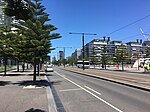
Wurundjeri Way in Docklands

Wurundjeri Way is a 1.9-kilometre (1.2 mi) road running through the Docklands Development west of the Melbourne central business district. It was constructed in 1999 as part of replanning and development of the former Melbourne rail yards and docks. Wurundjeri Way runs from Montague Street, South Melbourne to Dudley Street, West Melbourne via the Charles Grimes Bridge. When the Melbourne Docklands were redeveloped in the 1990s, Footscray Road was closed as a through route and rebuilt as Harbour Esplanade. To replace the through route, Wurundjeri Way was constructed to the east. To connect to this new road Flinders Street was upgraded, and the north end of the Charles Grimes Bridge was rebuilt on a curve to connect to it. Reconstruction started in June 1999, and was completed by 2001. A feature of the road, and integral to its design and naming, is the gigantic statue of Bunjil the eagle, by Melbourne sculptor Bruce Armstrong which was constructed in the median at the south end of the road. Proposals to develop this area for new buildings including the air rights over Wurundjeri Way, may require the statue to be moved.

Excerpt from the Wikipedia article Wurundjeri Way (License: CC BY-SA 3.0, Authors, Images).

Wurundjeri Way
Wurundjeri Way, Melbourne Docklands

Geographical coordinates (GPS) Address Nearby Places
placeShow on map

Wikipedia: Wurundjeri WayContinue reading on Wikipedia

Geographical coordinates (GPS)

Latitude Longitude
N -37.8168 ° E 144.9497 °
placeShow on map

Address

Wurundjeri Way (Docklands Highway)

Wurundjeri Way
3008 Melbourne, Docklands
Victoria, Australia
mapOpen on Google Maps

Wurundjeri Way in Docklands
Share experience

Nearby Places

Southern Cross railway station

Southern Cross railway station (until 2005 known as Spencer Street station) is a major railway station in Docklands, Melbourne. It is on Spencer Street, between Collins and La Trobe Streets, at the western edge of the Melbourne central business district. The Docklands Stadium sports arena is 500 metres north-west of the station. The station is owned, operated and maintained by Civic Nexus, a subsidiary of IFM Investors and operating as Southern Cross Station Pty Ltd, under a 30-year lease to 2036 from the Victorian State Government, as part of a public-private partnership. Southern Cross Station Pty Ltd contracts Infranexus Management Pty Ltd (Infranexus) for management services. Infranexus is also wholly owned by IFM.The station is the terminus of the state's regional railway network operated by V/Line, The Overland rail service to Adelaide, and NSW TrainLink XPT services to Sydney. It is also served by suburban rail services operated by Metro Trains, being one of five stations on the City Loop, a mostly underground railway that encircles the Central Business District. It is the second busiest railway station in Melbourne's metropolitan network, with 18.614 million passenger movements recorded in 2017/18. This figure excludes V/Line passengers who use the station. Southern Cross also has a coach terminal underneath the Spencer Outlet shopping complex. Skybus Super Shuttle services to Melbourne Airport and since 2017 to Avalon Airport operate from there, as well as Firefly Express and Greyhound Australia interstate coach services, a coach ran public bus (684) and V/Line coach services to Mildura, Yarram, Mansfield, and other parts of Victoria not served by rail.

Docklands, Victoria
Docklands, Victoria

Docklands (also known as Melbourne Docklands to differentiate it from London Docklands) is an inner suburb of Melbourne, Victoria, Australia, 2 km (1.2 mi) west of the city's Central Business District (CBD). Its local government area is the City of Melbourne. At the 2016 Census, Docklands had a population of 10,964. Primarily a waterfront area centred on the banks of the Yarra River, it is bounded by Wurundjeri Way and the Charles Grimes Bridge to the east, CityLink to the west and Lorimer Street across the Yarra to the south. The site of modern-day Docklands was originally swamp land that in the 1880s became a bustling dock area as part of the Port of Melbourne, with an extensive network of wharfs, heavy rail infrastructure and light industry. Following the containerisation of shipping traffic, Docklands fell into disuse and by the 1990s was virtually abandoned, making it the focal point of Melbourne's underground rave scene. The construction of Docklands Stadium in the late 1990s attracted developer interest in the area, and urban renewal began in earnest in 2000 with several independent privately developed areas overseen by VicUrban, an agency of the Victorian Government. Docklands subsequently experienced an apartment boom and became a sought-after business address, attracting the national headquarters of, among others, the National Australia Bank, ANZ, Medibank and the Bureau of Meteorology, as well as the regional headquarters for Ericsson and Bendigo Bank.Known for its striking contemporary architecture, the suburb is home to a number of heritage buildings that have been retained for adaptive reuse, and is also the site of landmarks such as the aforementioned Docklands Stadium, Southern Cross Station and the Melbourne Star Observation wheel. Although still incomplete, Docklands' developer-centric planning has split public opinion with some lamenting its lack of green open space, pedestrian activity, transport links and culture.