place

Edith Weston Priory

12th-century establishments in EnglandBenedictine monasteries in EnglandChristian monasteries established in the 12th centuryMonasteries in RutlandUse British English from August 2021
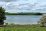
Small bay near Edith Weston geograph.org.uk 1005363

Edith Weston Priory was a small alien house of Benedictine monks in Edith Weston, Rutland. The French parent house of Abbey of Saint-Georges, Boscherville was founded by Ralf de Tanquerville, chamberlain to William the Conqueror, about the year 1050. By 1114 his son William donated the church and manor at Edith Weston, and a small cell of monks was set up to collect the rents and intercede for the founder's soul.The cell was one of two in England: William founded Avebury Priory in Wiltshire around the same time. Like all alien houses, control (and revenues) passed to the Crown in time of war with France, and it was during one of these periods that the priory closed. The last known Prior was in 1361, and by 1394 the church and manor had been sold to St. Anne's Priory, Coventry, bringing the priory to an end.Pevsner was dismissive of the priory, saying that Brooke Priory was the only monastery in Rutland as "Edith Weston hardly counts as one".The earthwork remains probably now lie below the waters of Rutland Water.

Excerpt from the Wikipedia article Edith Weston Priory (License: CC BY-SA 3.0, Authors, Images).

Edith Weston Priory
Weston Road,

Geographical coordinates (GPS) Address Nearby Places
placeShow on map

Wikipedia: Edith Weston PrioryContinue reading on Wikipedia

Geographical coordinates (GPS)

Latitude Longitude
N 52.6405 ° E -0.6347 °
placeShow on map

Address

Weston Road

Weston Road
LE15 8HE , Edith Weston
England, United Kingdom
mapOpen on Google Maps

Small bay near Edith Weston geograph.org.uk 1005363
Share experience

Nearby Places

Rutland
Rutland

Rutland (), archaically Rutlandshire, is a ceremonial county in the East Midlands of England. It borders Leicestershire to the north and west, Lincolnshire to the north-east, and Northamptonshire to the south-west. Oakham is the largest town. Rutland has an area of 382 km2 (147 sq mi) and a population of 41,049, the second-smallest ceremonial county population after the City of London. The county is rural, and the only towns are Oakham (12,149) and Uppingham (4,745), both in the west of the county; the largest settlement in the east is the village of Ketton (1,926). For local government purposes Rutland is a unitary authority area. The county was historically the smallest in England, a fact reflected in the motto of the county council: Multum in Parvo, or "much in little".The geography of Rutland is characterised by low, rolling hills, the highest of which is a 197 m (646 ft) point in Cold Overton Park. In the 1970s a large artificial reservoir, Rutland Water, was created in the centre of the county. It is now a nature reserve, serving as an overwintering site for wildfowl and a breeding site for ospreys. The older buildings in the county are built from local limestone or ironstone, and many have roofs of Collyweston stone slate or thatch. There is little evidence of Prehistoric settlement in the county, though Roman habitation is suggested by the discovery of a large Roman mosaic and probable farming complex just west of Ketton. It was certainly settled by the Angles from the fifth century and later formed part of Mercia. It is not mentioned as a distinct county until 1179, and during the Domesday Survey was treated as part of Nottinghamshire and Northamptonshire. During the High Middle Ages much of the county was forested and used as hunting grounds, a tradition which continues to the present with packs such as the Cottesmore Hunt. The county's main industry is agriculture, with wool being particularly important in the sixteenth century, and there is a limestone quarry near Ketton. Rutland bitter is a distinctive ale associated with the village of Langham.

Normanton, Rutland
Normanton, Rutland

Normanton is a village and civil parish on the eastern shore of Rutland Water in the county of Rutland in the East Midlands of England. The population remained less than 100 at the 2011 census and was included in the civil parish of Edith Weston. Normanton Hall was a seat of the Earls of Ancaster and an important centre of their estates. The stable block of their hall is now Normanton Park hotel. In the 18th century the village was cleared to make a park for the estate of the Heathcote family with the population mainly re-housed in Empingham. The village's name means 'farm/settlement of the Norwegian Vikings'.In the 1970s much of the parish was flooded by the construction of the Rutland Water reservoir. St Matthew's Church is a Grade II listed building, built in classical style. The tower and the western portico were built by Thomas Cundy Jr between 1826 and 1829, based on the design of St John's, Smith Square in Westminster, while the nave and apse were constructed in 1911, by J. B. Gridley of London. The building was once the private chapel for the Normanton Estate, but it was de-consecrated in 1970, and was to have been demolished as part of the reservoir construction, as its floor was below the proposed water level. Following a public outcry, the lower half was filled with stone and rubble, and a concrete cap constructed just below the level of the windows. An embankment was built around the church leaving it a prominent feature on the water's edge. The structure formerly housed a museum recording the history of Rutland Water, which is now located in the visitor centre. The structure is now used as a venue for civil weddings and concerts. Normanton is the name of a ward of Rutland County Council, returning two councillors. The ward includes Edith Weston, Empingham, North Luffenham and South Luffenham.