place

Salem Harbor Power Station

Coal-fired power stations in MassachusettsCompanies that filed for Chapter 11 bankruptcy in 2022Energy stubsSalem, Massachusetts
Salem Harbor Station Natural Gas Plant

Salem Harbor Power Station is a natural gas-fired power plant located in Salem, Massachusetts. It replaced an outdated coal-fired plant on the same site and went online in May 2018.The facility sits on land reclaimed during the 1800s, and was previously the site of a wharf and coal depository. Construction on the original plant began in the 1950s, and was expanded numerous times. It is smaller than the original plant, allowing 40-acres of waterfront land to be used for future development. The 60-year-old coal plant, which was purchased by Footprint Power in 2012, was brought offline on May 31, 2014. Demolition work was completed in 2016, while the new plant was being built around it.On March 23, 2022, the development company filed for Chapter 11 bankruptcy.

Excerpt from the Wikipedia article Salem Harbor Power Station (License: CC BY-SA 3.0, Authors, Images).

Salem Harbor Power Station
Fort Avenue, Salem

Geographical coordinates (GPS) Address Nearby Places
placeShow on map

Wikipedia: Salem Harbor Power StationContinue reading on Wikipedia

Geographical coordinates (GPS)

Latitude Longitude
N 42.526313888889 ° E -70.876505555556 °
placeShow on map

Address

Fort Avenue 50
01970 Salem
Massachusetts, United States
mapOpen on Google Maps

Salem Harbor Station Natural Gas Plant
Share experience

Nearby Places

Fort Lee (Salem, Massachusetts)

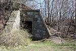
Fort Lee is a historic American Revolutionary War fort in Salem, Massachusetts. The site, located at a high point next to Fort Avenue on Salem Neck, is a relatively rare fortification from that period whose remains are relatively unaltered. It is an irregular 5-pointed star fort. Although there is some documentary evidence that the Neck was fortified as early as the 17th century, the earthworks built in 1776 are the first clear evidence of the site's military use. Reportedly, the fort had a garrison of 3 officers and 100 artillerymen with 16 guns. The site, of which only overgrown earthworks and a stone magazine survive, was repaired in the 1790s, and rebuilt for the American Civil War. A state cultural resource document states that the fort has not been much modified since the Revolution, and has not been built over. It was garrisoned by the Massachusetts militia in the War of 1812, abandoned afterwards, and rebuilt with four 8-inch columbiads in the Civil War. An Army engineer drawing dated 1872 depicts the fort's five-pointed trace and the four Civil War gun positions. It was also garrisoned during the Spanish–American War.The property was federalized in 1867, and transferred to the City of Salem in 1922. The site was briefly rehabilitated at the time of the United States bicentennial in 1976, with trails and interpretive signs, but these were later removed, and the site has again become overgrown. Earthworks and a stone magazine remain. The fort site was listed on the National Register of Historic Places in 1994.