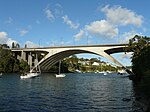
Gladesville Bridge

Gladesville Bridge is a heritage-listed concrete arch road bridge that carries Victoria Road over the Parramatta River, linking the Sydney suburbs of Huntleys Point and Drummoyne, in the local government areas of Canada Bay and Hunter's Hill, in New South Wales, Australia. Despite its name, the bridge is not in Gladesville. The Gladesville Bridge is a few kilometres upstream of the famous Sydney Harbour Bridge. When it was completed in 1964, Gladesville Bridge was the longest single span concrete arch ever constructed. Gladesville Bridge is the largest of a complex of three bridges, including Fig Tree Bridge and Tarban Creek Bridge, designed to carry traffic as part of the North Western Expressway. The bridge was the first phase of this freeway project that was to connect traffic from the Newcastle via Wahroonga/Lane Cove, then through Glebe/Annandale to connect into the city. Due to community action the freeway project was abandoned by the Wran Government in 1977, leaving the Gladesville Bridge connecting the existing arterial roads.The Gladesville Bridge was designed by Anthony Gee, G. Maunsell & Partners and Eugène Freyssinet and built from 1959 to 1964 by Reed & Mallik (Engineers, England) and Stuart Bros (Builders, Sydney). The property is owned by Transport for NSW. The bridge was added to the New South Wales State Heritage Register on 1 October 2014.
Excerpt from the Wikipedia article Gladesville Bridge (License: CC BY-SA 3.0, Authors, Images).Gladesville Bridge
Drummoyne Avenue, Sydney Drummoyne
Geographical coordinates (GPS) Address External links Nearby Places Show on map
Geographical coordinates (GPS)
| Latitude | Longitude |
|---|---|
| N -33.842 ° | E 151.1477 ° |
Address
Gladesville Bridge
Drummoyne Avenue
2047 Sydney, Drummoyne
New South Wales, Australia
Open on Google Maps


