place

Joint Base Langley–Eustis
2010 establishments in VirginiaAirports in VirginiaBuildings and structures in Newport News, VirginiaJoint bases of the U.S. Department of DefenseMilitary Superfund sites
Military installations in VirginiaPopulated places on the James River (Virginia)Superfund sites in VirginiaUse American English from March 2022
Langley AFB
Langley AFB

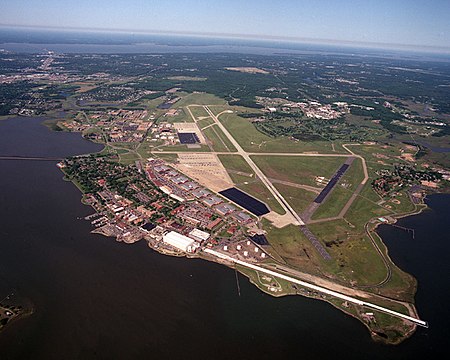
Joint Base Langley–Eustis (IATA: LFI/FAF, ICAO: KLFI/KFAF, FAA LID: LFI/FAF) is a United States military facility located adjacent to Hampton and Newport News, Virginia. The base is an amalgamation of the United States Air Force's Langley Air Force Base and the United States Army's Fort Eustis which were merged on 1 October 2010. The base was established in accordance with congressional legislation implementing the recommendations of the 2005 Base Realignment and Closure Commission. The legislation ordered the consolidation of the two facilities which were nearby, but separate military installations, into a single Joint Base, one of 12 formed in the United States as a result of the law. Unlike other joint bases that share common perimeters, the two components are geographically separated by 17 miles. In January 2010, the Air Force reactivated the 633rd Air Base Wing to assume host unit and installation support functions at each location. The installation assumed its full operational capability (FOC) in October 2010. The 633rd ABW commander is Col Gregory Beaulieu, and Chief Master Sgt. Kennon D. Arnold is its command chief master sergeant. The 633rd ABW is responsible to Air Combat Command.

Excerpt from the Wikipedia article Joint Base Langley–Eustis (License: CC BY-SA 3.0, Authors, Images).

Joint Base Langley–Eustis
Poulas Court, Hampton

Geographical coordinates (GPS) Address Nearby Places
placeShow on map

Wikipedia: Joint Base Langley–EustisContinue reading on Wikipedia

Geographical coordinates (GPS)

Latitude Longitude
N 37.082777777778 ° E -76.360555555556 °
placeShow on map

Address

Langley Air Force Base (Joint Base Langley-Eustis)

Poulas Court
23669 Hampton
Virginia, United States
mapOpen on Google Maps

Langley AFB
Langley AFB
Share experience

Nearby Places

Full-Scale Wind Tunnel

The Full-Scale Tunnel (abbreviated FST, also known as the 30-by 60-Foot Tunnel) was a wind tunnel at NASA's Langley Research Center. It was a National Historic Landmark. In 1929, National Advisory Committee for Aeronautics began construction of the world's first full-scale wind tunnel. The design team was led by Smith J. DeFrance. The tunnel was completed in 1931 (dedicated 27 May) at a cost just under $900,000. It was a double-return tunnel capable of moving air at speeds up to 118 miles/hour (190 km/h) through its circuit. It had a 30 ft by 60 ft (9.1 m x 18.3 m) open throat, which is capable of testing aircraft with spans of 40 ft (12.2 m). The wind tunnel was a double-return, atmospheric pressure tunnel with two fans powered by 4,000 hp electric motors. The Vought O3U-1 biplane observation airplane was the first complete airplane tested in the tunnel. After that, it was used to test virtually every high-performance aircraft used by the United States in World War II. For much of the war, when it was operational 24 hours a day, seven days a week, the full-scale tunnel was the only tunnel in the free world large enough to perform these tests. After the war, many types of aircraft were tested in the tunnel including the Harrier jump jet fighter, the F-16, the American supersonic transport, the Space Shuttle and Lunar Landing Test Vehicle. During the 1950s and 1960s, the tunnel was modified and upgraded several times. The principal improvement was adding the ability to test free-flying scale models in the test throat. The wind tunnel was in use through the 2000s, testing procedures such as free-flight and high angle of attack.It was declared a National Historic Landmark in 1985. However, despite this designation and the efforts of some aviation historians, demolition of the tunnel began in 2010. It was documented before its demolition, with the fan blades being salvaged for display. In 2014 its landmark designation was withdrawn and it was removed from the National Register of Historic Places.

Eight-Foot High Speed Tunnel

The Eight-Foot High Speed Tunnel, also known as Eight-Foot Transonic Tunnel, was a wind tunnel located in Building 641 of NASA's Langley Research Center in Hampton, Virginia. It was a National Historic Landmark.The tunnel was completed in 1936 at a cost of $36,266,000. Because of its high speed and Bernoulli's principle, the pressure in the test section is much lower than that in the rest of the tunnel. This required a structure that could withstand an inward force due to the pressure difference. Instead of steel construction, it was built from reinforced concrete with walls up to 1 ft (0.3 m) thick. This resulted in an "igloo-like" structure at the test section. The wind tunnel was designed as a single-return tunnel capable of moving air at speeds up to a Mach number up to 0.75. It was powered by an 8,000 hp (6,000 kW) electric motor. It was repowered to 16,000 hp (12,000 kW) to give Mach number 1 capability in 1945. In 1947, the speed was increased to a Mach number of 1.2 with the installation of a contoured nozzle. In 1950, a slotted-throat test section was installed, and it was repowered to 25,000 hp (19,000 kW). Because it was the first continuous-flow high-speed tunnel, this tunnel was a landmark in wind tunnel design. This meant it could operate almost indefinitely to produce a high-speed airstream approaching the speed of sound. And it was large enough to accommodate large-scale models and even full-scale aircraft sections. In 1950, the tunnel was the first in the world to be modified to incorporate a slotted throat design. This revolutionary design gave researchers their first accurate data on airframe performance in the transonic range. The tunnel was deactivated in 1956, when a new 8-foot (2.4 m) tunnel was built near it. The wind tunnel was used for critical tests that validated the area rule for the design of supersonic aircraft. This said that the fuselage of the aircraft should narrow at the wings and expand at their trailing edges. This resulted in "wasp-waisted" aircraft. The tunnel was taken out of service in 1956. It was declared a National Historic Landmark in 1985. In 2011, Building 641, which housed the tunnel, was demolished. The landmark designation was withdrawn in 2014, and it was removed from the National Register of Historic Places.There are additional photographs of the wind tunnel in the Historic American Engineering Record collection.

Back River (Virginia)

The Back River is an estuarine inlet of the Chesapeake Bay between the independent cities of Hampton and Poquoson in the Hampton Roads area of southeastern Virginia. Formed by the confluence of the Northwest and Southwest Branches, and at just over two miles (3.2 km) long, the Back River is a breeding ground for many of the Bay's prized sport fish and the well known blue crab. The river was once part of an important fishing area that provided the local canneries with the famous Chesapeake seafood that was, and still is in demand throughout the country. Although now used primarily for recreation and as a wildlife refuge, the river remains a great place to spend an afternoon with a fishing rod or a few crab traps. Factory Point, a peninsula that protects the river from the Chesapeake Bay sits at the mouth of the river adjoining the bay. The Southwest Branch begins as Newmarket Creek, a marshy, tidal creek which flows from its headwaters in Newport News into Hampton where it widens greatly and empties into the river. The Northwest Branch also begins in Newport News as Brick Kiln Creek and is dammed along with the Hampton city and York County border to form Big Bethel Reservoir. It flows from the reservoir into Poquoson, where it becomes the Northwest Branch. The Back River Lightstation, or Grandview Light, formerly stood on a windswept beach at the mouth of the river. Constructed in 1829 by Winslow Lewis, with a cost of $4,250, the thirty-foot brick tower displayed its light until 1915, when it was automated and the keepers removed. In 1936, the station was decommissioned and left open to the elements and vandals. Hurricane Flossy in 1956 delivered the final blow and toppled the tower. All that can be seen today is a pile of debris just off the beach.

Langley Speedway (Virginia)

Langley Speedway is a race track located in Hampton, Virginia, United States. Langley Speedway is a paved short track measuring 4/10 mile in length. It is one of the flattest tracks in the region with only six degrees of banking in the corners and two degrees of banking on the straights. In November 1970, it became the site of the last NASCAR Grand National Series race before the series was renamed the Winston Cup. The track is located in front of NASA's Langley Research Center on Commander Sheppherd Boulevard. The track is NASCAR sanctioned and participates in the NASCAR Advance Auto Parts Weekly Series, which determines a national champion for the NASCAR sanctioned local tracks. The track hosts 12 divisions that alternate running during their Saturday night program: Late models, Modifieds, Virginia Racers, legends cars, Super Streets, Enduros, Grand Stocks, Super Trucks, UCARS, Pro Six, Bandoleros, and HRKC Pro Winged Champ Karts. Pre race ceremonies for the regular Saturday night events begin at approximately 7:00 PM with the first race of the night beginning about 15 minutes later. Langley also hosts Hampton Roads Kart Club races on most Sundays and some Fridays during the season, Wacky Wednesday which allows anyone with a helmet and a street legal car to participate in the time attack, burnout competition, and one on one drag races on most Wednesday nights during the season, the Langley Drift Club which helped bring drifting to the Hampton Roads’ area, and starting in 2023 Old-Dominion Region-SCCA Autocross events.