7th Ward of New Orleans
Neighborhoods in New OrleansUse mdy dates from August 2023Wards of New Orleans

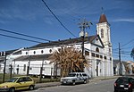
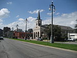
The 7th Ward (Seventh Ward) is a legally defined voting ward and a neighborhood of the city of New Orleans. A sub-district of the Mid-City District Area, its boundaries as defined by the New Orleans City Planning Commission are: A.P. Tureaud Avenue, Agriculture, Allen, Industry, St. Anthony, Duels, Frenchmen and Hope Streets to the north, Elysian Fields Avenue to the east, St. Claude and St. Bernard Avenues, North Rampart Street and Esplanade Avenue to the south, and North Broad Street to the west. The voting ward is geographically the third largest of the 17 Wards of New Orleans, after the 9th Ward and 15th Ward.
Excerpt from the Wikipedia article 7th Ward of New Orleans (License: CC BY-SA 3.0, Authors, Images).7th Ward of New Orleans
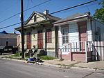
Old Prieur Street, New Orleans
Geographical coordinates (GPS) Address Nearby Places Show on map
 Continue reading on Wikipedia
 Geographical coordinates (GPS)
| Latitude | Longitude |
|---|---|
| N 29.977222222222 ° | E -90.065555555556 ° |
Address
Old Prieur Street 1818
70116 New Orleans
Louisiana, United States
Open on Google Maps