Nieuw Binckhorst
Geography of The HagueMixed-use developments in the NetherlandsNew Urbanism communities
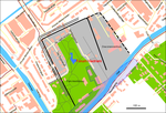
Nieuw Binckhorst is a former industrial area in southeast The Hague, Netherlands, originally called Binckhorst, for which a plan was adopted in 2009 to transform 99.5 hectares (246 acres) into a mixed-use development along the lines of New Urbanism, including residential, employment and entertainment components and with Randstadrail regional light rail service. The Hague's long-term plan Structuurvisie 2020, "Structural Vision 2020", sees Nieuw Binckhorst as a future part of the city center of The Hague. It is seen as fundamental to the realization of the international ambitions of The Hague, and of the Randstad conurbation.
Excerpt from the Wikipedia article Nieuw Binckhorst (License: CC BY-SA 3.0, Authors).Nieuw Binckhorst
Wegastraat, The Hague Laak
Geographical coordinates (GPS) Address Nearby Places Show on map
Geographical coordinates (GPS)
| Latitude | Longitude |
|---|---|
| N 52.0689 ° | E 4.3414 ° |
Address
Wegastraat 29
2516 AN The Hague, Laak
South Holland, Netherlands
Open on Google Maps


