place

GSM London

1973 establishments in EnglandBusiness schools in EnglandCompanies that have entered administration in the United KingdomEducation in the Royal Borough of GreenwichEducational institutions established in 1973
Higher education colleges in LondonUse British English from April 2018

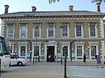
GSM London (formerly Greenwich School of Management (GSoM)) was a private provider of higher education based in Greenwich, south-east London, and Greenford, west London. Founded in 1973, it offered business-specific courses at undergraduate and postgraduate levels alongside other specialist training, and catered to a large number of international students. As of 2019, GSM London had educated over 20,000 students. It was owned by the private equity firm Sovereign Capital.On 30 July 2019, GSM London was placed into administration, and ceased all teaching and student support services by the end of November 2019.

Excerpt from the Wikipedia article GSM London (License: CC BY-SA 3.0, Authors).

GSM London
Royal Hill, London

Geographical coordinates (GPS) Address Nearby Places
placeShow on map

Wikipedia: GSM LondonContinue reading on Wikipedia

Geographical coordinates (GPS)

Latitude Longitude
N 51.4781 ° E -0.0109 °
placeShow on map

Address

Royal Hill
SE10 8EX London (Royal Borough of Greenwich)
England, United Kingdom
mapOpen on Google Maps

Share experience

Nearby Places

Greenwich Park railway station

Greenwich Park was a railway station opened in 1888 by the London, Chatham and Dover Railway (LCDR) in Greenwich, south-east London. The station was originally called Greenwich and the LCDR intended it to rival a nearby station also named Greenwich which was owned by the South Eastern Railway (SER) and which had opened over 50 years earlier. The LCDR's station was the terminus of a branch line from Nunhead.Despite being in a prime location (on Stockwell Street) the LCDR station failed to attract sufficient passengers, possibly because the rival SER station offered a shorter journey time into central London. In 1899 the LCDR was amalgamated with the SER (as the South Eastern & Chatham Railway), and in 1900 the LCDR station was renamed Greenwich Park to distinguish it from the SER's original Greenwich station. Due to wartime economy measures, Greenwich Park was closed in 1917. The section of the branch between Nunhead and Lewisham Road was reopened in 1929 by the Southern Railway with a new connecting spur to Lewisham, providing another route into central London. The section between Lewisham Road and Greenwich Park was officially abandoned in 1929. After 1929 the station was demolished and the cutting occupied by the trackbed and platforms was infilled. Today the site is occupied by a hotel and its car park. Nothing remains of the railway north-east of the closed Lewisham Road station except for a short section of embankment adjacent to St Johns.

King William Walk
King William Walk

King William Walk is a street in central Greenwich in London. It runs northwards from the entrance to Greenwich Park along the edge of the Old Royal Naval College to the Cutty Sark and the nearby Greenwich foot tunnel. The western side of the street comprises a mixture of residential and commercial properties, with several shops, restaurants and, south of Nelson Road, two pubs. The eastern side includes the Discover Greenwich Visitor Centre and several former College buildings and open spaces today used by the University of Greenwich, including residential accommodation in Devonport House, south of Nelson Road. The street was originally part of the Medieval centre of Greenwich and was known as Friars Road after a pre-Reformation Franciscan friary built to the west of the Palace of Placentia. The street was known during the eighteenth century as King Street, but was partly redeveloped and extended during the 1820s when central Greenwich was rebuilt. This process also saw the construction of Nelson Road (1829) and College Approach (1836) and the establishment of a new Greenwich Market.The street contains several surviving eighteenth century buildings. At the northern end is a statue of William IV, which was created by Samuel Nixon. Originally it stood in King William Street in the City of London but was relocated to Greenwich in 1935. It stands where St Mary's Church, designed by George Basevi, was located from 1823 to 1935. At the southern end, by the Greenwich Tavern pub, King William Walk is joined by the short Nevada Street; from Nevada Street's western end, Croom's Hill runs southwards up the west side of Greenwich Park towards Blackheath, London.