place

Old Street station

DfT Category E stationsFormer City and South London Railway stationsFormer Great Northern and City Railway stationsLondon station groupLondon stations without latest usage statistics 1415
London stations without latest usage statistics 1516Northern line stationsRail transport stations in London fare zone 1Railway stations in Great Britain closed in 1975Railway stations in Great Britain opened in 1901Railway stations in Great Britain opened in 1904Railway stations in Great Britain opened in 1976Railway stations in the London Borough of IslingtonRailway stations located underground in the United KingdomTube stations in the London Borough of IslingtonUnopened Northern Heights extension stationsUse British English from August 2012
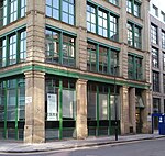
Old Street stn southeast entrance

Old Street is a National Rail and London Underground station at the junction of Old Street and City Road in central London, England. The station is on the Bank branch of the Northern line between Moorgate and Angel stations and on the Northern City Line between Moorgate and Essex Road stations. The station is in the London Borough of Islington (straddling the Hackney border). It is in Travelcard Zone 1. The station was built by the City and South London Railway and opened in 1901. It was rebuilt by Stanley Heaps in 1925 with a more uniform frontage, and again in 1968, replacing all surface buildings with a subsurface complex. In 2014, it was redeveloped to provide more retail space. Old Street station has become busier, attracting over 20 million visitors in 2014; a trend expected to continue following redevelopment of the local area as a centre for the British Information Technology industry.

Excerpt from the Wikipedia article Old Street station (License: CC BY-SA 3.0, Authors, Images).

Old Street station
Old Street Roundabout, London Finsbury (London Borough of Islington)

Geographical coordinates (GPS) Address Nearby Places
placeShow on map

Wikipedia: Old Street stationContinue reading on Wikipedia

Geographical coordinates (GPS)

Latitude Longitude
N 51.52581 ° E -0.08709 °
placeShow on map

Address

Old Street Roundabout

Old Street Roundabout
EC1Y 1BE London, Finsbury (London Borough of Islington)
England, United Kingdom
mapOpen on Google Maps

Old Street stn southeast entrance
Share experience

Nearby Places

Bunhill Fields
Bunhill Fields

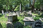
Bunhill Fields is a former burial ground in central London, in the London Borough of Islington, just north of the City of London. What remains is about 1.6 hectares (4.0 acres) in extent and the bulk of the site is a public garden maintained by the City of London Corporation. It was first in devoted use as a burial ground from 1665 until 1854, in which period approximately 123,000 interments were estimated to have taken place. Over 2,000 monuments remain, for the most part in concentrated blocks. It was a prototype of land-use protected, nondenominational grounds, and was particularly favoured by nonconformists who passed their final years in the region. It contains the graves of many notable people, including John Bunyan (died 1688), author of The Pilgrim's Progress; Daniel Defoe (died 1731), author of Robinson Crusoe; William Blake (died 1827), artist, poet, and mystic; Susanna Wesley (died 1742), known as the "Mother of Methodism" through her education of sons John and Charles; Thomas Bayes (died 1761), statistician and philosopher; and Isaac Watts (died 1748), the "Father of English Hymnody". Bunhill Fields Burial Ground is listed Grade I on the Register of Historic Parks and Gardens. It is now maintained by the Friends of the City Gardens. Nearby, on the west side of Bunhill Row and behind the residential tower Braithwaite House, is a former Quaker burial ground, in use from 1661 to 1855, at times also known as Bunhill Fields. George Fox (died 1691), one of the founders of the movement, is among those buried there. Its remains are also a public garden, Quaker Gardens, managed by the London Borough of Islington.