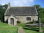
Upper Midhope
Towns and villages of the Peak DistrictUse British English from July 2018Villages in South YorkshireVillages of the metropolitan borough of Sheffield

Upper Midhope (archaic Over Midhope) is a village in the civil parish of Bradfield within the Stocksbridge and Upper Don electoral ward in the borough of the City of Sheffield, England. It lies just on the edge of the Peak District national park. Historically the habitation, together with Nether Midhope (Midhopestones), were collectively known as Midhope.
Excerpt from the Wikipedia article Upper Midhope (License: CC BY-SA 3.0, Authors, Images).Upper Midhope
Midhope Lane, Sheffield Bradfield
Geographical coordinates (GPS) Address Nearby Places Show on map
Geographical coordinates (GPS)
| Latitude | Longitude |
|---|---|
| N 53.494 ° | E -1.675 ° |
Address
Midhope Lane
S36 4GX Sheffield, Bradfield
England, United Kingdom
Open on Google Maps


