West Cross Route

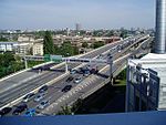
The West Cross Route (WCR) is a 0.75 mile (1.2km) segment of dual carriageway section of the A3220 route in central London in The Royal Borough of Kensington and Chelsea, with a small part being shared with borderlining borough Hammersmith and Fulham. It runs north–south between the northern elevated roundabout junction with the western end of Westway (A40) and the southern Holland Park Roundabout. It opened in 1970, together with Westway. The WCR was formerly the M41 motorway. Its status was downgraded to an A-road in 2000 when responsibility for trunk roads in Greater London was transferred from the Highways Agency to the Greater London Authority. Approximately halfway along the road's length a new junction was built to serve the Westfield London shopping development. The WCR was originally the designation for the western section of Ringway 1, the innermost circuit of the London Ringways network, a complex and comprehensive plan for a network of high-speed roads circling central London designed to manage and control the flow of traffic within the capital. The road would have run from Battersea to Harlesden and would have paralleled the National Rail West London Line as an elevated road. Although the road no longer has motorway status, pedal cycles are prohibited by a sign at Holland Park roundabout.
Excerpt from the Wikipedia article West Cross Route (License: CC BY-SA 3.0, Authors, Images).West Cross Route
West Cross Route, London North Kensington (London Borough of Hammersmith and Fulham)
Geographical coordinates (GPS) Address Nearby Places Show on map
Geographical coordinates (GPS)
| Latitude | Longitude |
|---|---|
| N 51.513055555556 ° | E -0.22083333333333 ° |
Address
Viaduct Junction
West Cross Route
W10 6TP London, North Kensington (London Borough of Hammersmith and Fulham)
England, United Kingdom
Open on Google Maps


