Büsingen am Hochrhein

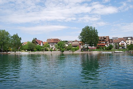
Büsingen am Hochrhein (German: [ˈbyːzɪŋən am ˈhoːxʁaɪn], lit. 'Büsingen on the Upper Rhine'; Alemannic: Büesinge am Hochrhi, pronounced [ˈbyəzɪŋə am ˈhoːçri]), often known simply as Büsingen, is a German municipality (7.62 km2 [2.94 sq mi]) in the south of Baden-Württemberg with a population of about 1,548 inhabitants. It is an exclave of Germany and Baden-Württemberg, and an enclave of Switzerland, entirely surrounded by the Swiss cantons of Schaffhausen, Zürich and Thurgau. It is separated from the rest of Germany by a narrow strip of land (at its narrowest, about 680 m [2,230 ft] wide) containing the Swiss village of Dörflingen. The distance to this enclave is approximately 5 km (3.1 mi) from the town of Schaffhausen and 3 km (1.8 mi) from Dörflingen, the nearest village. Its status as an exclave dates back to before the formation of the modern German and Swiss states, having previously been a detached part of Further Austria, the Kingdom of Württemberg and the Grand Duchy of Baden. Politically Büsingen is part of Germany, forming part of the district of Konstanz, but economically it forms part of the Swiss customs union, along with the principality of Liechtenstein and up until 2019, albeit unofficially, the Italian village of Campione d'Italia. As such there have been no border controls between Switzerland and Büsingen since 4 October 1967.Büsingen is a holiday destination for much of the year and attracts a significant number of visitors from around the region as well as from further afield, for its recreational areas along the Rhine and proximity to the Rheinfall waterfalls in nearby Neuhausen am Rheinfall. Many dwellings in Büsingen are holiday flats that are accompanied by a number of small guest houses.
Excerpt from the Wikipedia article Büsingen am Hochrhein (License: CC BY-SA 3.0, Authors, Images).Büsingen am Hochrhein
Junkerstraße, Verwaltungsgemeinschaft Gottmadingen
Geographical coordinates (GPS) Address Nearby Places Show on map
Geographical coordinates (GPS)
| Latitude | Longitude |
|---|---|
| N 47.696944444444 ° | E 8.6902777777778 ° |
Address
Junkerstraße 60
78266 Verwaltungsgemeinschaft Gottmadingen
Baden-Württemberg, Germany
Open on Google Maps


