Dent du Chamois
Canton of Fribourg geography stubsMountains of SwitzerlandMountains of the AlpsMountains of the canton of Fribourg

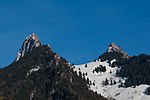
The Dent du Chamois (1,839 m) is a mountain of the Swiss Prealps, located east of Gruyères in the canton of Fribourg. It lies on the range north of the Vanil Noir, between the valleys of the Sarine and the Motélon. From the col of La Forcla (1,546 m), a trail leads to its summit.
Excerpt from the Wikipedia article Dent du Chamois (License: CC BY-SA 3.0, Authors, Images).Dent du Chamois
Ciernedon d'Enbas, Bas-Intyamon
Geographical coordinates (GPS) Address Nearby Places Show on map
Geographical coordinates (GPS)
| Latitude | Longitude |
|---|---|
| N 46.584444444444 ° | E 7.1313888888889 ° |
Address
Col des Combes
Ciernedon d'Enbas
1665 Bas-Intyamon
Fribourg, Switzerland
Open on Google Maps


