place

Fremantle Long Jetty
1873 establishments in Australia1910 disestablishments in AustraliaFremantle HarbourHeritage places in FremantleJetties in Perth, Western Australia
Use Australian English from May 2013
Masonfreojetty1890c
Masonfreojetty1890c

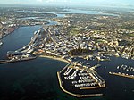
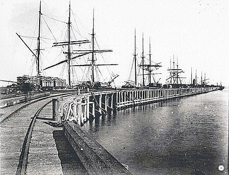
Fremantle Long Jetty was constructed in 1873 to replace the smaller South Jetty which had become too small for the large amounts of vessels entering the colony in Western Australia. The jetty lies in Bather's Bay which has been an occupation site since the Swan River Colony was established in 1829. It was a centre of trade and communications that served Fremantle and Perth until Fremantle Harbour was opened. An increased amount of shipping made it necessary to improve the harbouring facilities by the late 1860s. Long Jetty was built as a less expensive alternative to building a harbour at the mouth of the Swan River due to a lack of funds and technological shortcomings.In July 1984 the Maritime Archaeology Department of the Western Australian Museum was notified of plans to construct a marina for the 1987 America's Cup that would be close to the remains of the Long Jetty. This prompted an archaeological excavation to ascertain the importance of the site.

Excerpt from the Wikipedia article Fremantle Long Jetty (License: CC BY-SA 3.0, Authors, Images).

Fremantle Long Jetty
Mews Road,

Geographical coordinates (GPS) Address Nearby Places
placeShow on map

Wikipedia: Fremantle Long JettyContinue reading on Wikipedia

Geographical coordinates (GPS)

Latitude Longitude
N -32.0589 ° E 115.741 °
placeShow on map

Address

Mews Road
6160
Western Australia, Australia
mapOpen on Google Maps

Masonfreojetty1890c
Masonfreojetty1890c
Share experience

Nearby Places

Arthur Head
Arthur Head

Arthur Head (also known as Arthur's Head) in Fremantle, Western Australia, is a former large limestone headland on the southern side of the mouth of the Swan River, now also the entry to Fremantle Harbour. Historian Bob Reece identifies the geographical prominence of the location in his entry in the Historical Encyclopedia of Western Australia:: 387  Fremantle is a narrow peninsula of land located at the estuary of the Swan River within Cockburn Sound, its principal landmarks from the sea being the limestone outcrop known as Arthur Head and the two hills known as Buckland Hill and Monument Hill (now Obelisk Hill). Also the strategic quality of the head is noted as: In May 1829 the strategic location of Arthur Head led it being chosen by Captain Charles Fremantle RN as the site for his fortified beach camp.: 4  It has been significantly altered since European settlement in the 1830s, and is the site of a large number of demolished structures.Archaeologist Michael Pearson in his 1984 report identified the following: 1851 Lighthouse (first) 1876 Lighthouse (second): 22 feet (6.7 m) in diameter, 72 feet (22 m) high; constructed by convicts in 1876–1879; decommissioned in 1902. 1834 Courthouse (first) 1840 Courthouse (second) 1852 Police station complex Lighthouse keeper quarters Harbourmaster quartersThe structures remaining on the head are the Round House, the oldest remaining building in Western Australia, and the pilots' cottages, all of which are heritage listed. Passing through Arthur Head is the Whalers Tunnel that enabled ease of access to Bathers Beach, Fremantle and the Long Jetty. A significant part of the Arthur Head area was utilised during World War II; the slipway constructed then for submarine repairs was known as the Arthurs Head Slipway.

Union Bank, Fremantle

The site of 4 High Street was purchased by the Union Bank of Australia in 1881 and for several years the bank operated from the existing building, which had been the residence of Captain Daniel Scott. A new building was erected in 1889 with plans prepared by Melbourne architect William Edward Robertson, the construction was supervised by James Wright. The bank built new premises further along High Street in 1930 and placed the existing building up for auction. It was advertised as having a 119-foot (36 m) frontage along High Street and a 64.5-foot (20 m) frontage along Cliff Street. The ground floor of the brick building had a large banking chamber, a manager's office, strongroom, entrance hall, dining room and kitchen. The first floor contained a drawing room, seven bedrooms, bathrooms and linen closet. There were balconies at both the front and rear of the building.In 1931 the property was purchased by the Church of England for the Flying Angel Mission to Seamen organisation. In December 1937 plans were approved for the construction of the St Andrew's Mariners Chapel to the west (along High Street) behind the former bank building. It was constructed by Hawkins & Son at a cost of £1,731 and continued to function as a chapel until the late 1960s. As of 2016 both buildings were owned and used by the University of Notre Dame Australia. The Flying Angel Club had moved to 76 Queen Victoria Street by 1968. It is within the Fremantle West End Heritage area.