place

Kualoa Regional Park

Beaches of OahuGeography of Honolulu County, HawaiiHawaii geography stubsHistory of OahuParks in Hawaii
Starr 050222 4235 Erythrina variegata

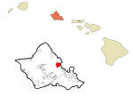
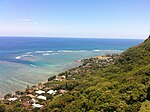
Kualoa Regional Park is located at Kāneʻohe Bay, on the island of Oahu in the U.S. state of Hawaii. The park covers 153 acres (61.92 ha; 0.24 sq mi) across the road from the Pali-ku (cliffs) of the Koʻolau Range. The beach front is white sand and 1/3 mile offshore is the small basalt island of Mokoliʻi (or Chinaman's Hat). The site is popular with watchers of wetland birds, such as the Japanese white-eye, Red-crested cardinal, White-rumped shama, Black-crowned night heron, Black-necked stilt, Nutmeg mannikin, Black noddy, Wedge-tailed shearwater, White-tailed tropicbird, Red-tailed tropicbird, Common myna, Common waxbill, Cattle egret and a variety of others.

Excerpt from the Wikipedia article Kualoa Regional Park (License: CC BY-SA 3.0, Authors, Images).

Kualoa Regional Park
Kualoa Park Drive,

Geographical coordinates (GPS) Address Nearby Places
placeShow on map

Wikipedia: Kualoa Regional ParkContinue reading on Wikipedia

Geographical coordinates (GPS)

Latitude Longitude
N 21.511 ° E -157.837 °
placeShow on map

Address

Kualoa Park Drive
96730
Hawaii, United States
mapOpen on Google Maps

Starr 050222 4235 Erythrina variegata
Share experience

Nearby Places

Molii Fishpond
Molii Fishpond

Moliʻi Fishpond is located southeast of Kamehameha Highway between Kualoa and Johnson Roads, near Kaneohe, on the island of Oahu, in the U.S. state of Hawaii. The pond encompasses 125 acres (50.59 ha; 0.20 sq mi) The locale is part of the ahupuaa (land division) of Hakipuu. The Molii pond is part of Kualoa Ranch. Tilapia, mullet and moi are found within the pond. Commercial fishing operations are contracted out.Ancient Hawaiian fishponds were noted in the 1826 journal of William Ellis, the naturalist on James Cook's third voyage (1776–1779): They [the Hawaiians] have numerous small lakes and ponds, frequently artificial, wherein they breed fish of various kinds, and in tolerable abundance. Moli'i, along with Huilua, Kahaluu and Heʻeia are the only four original Hawaiian fishponds remaining on Oahu. Fishponds were used by the ancient Hawaiians for ocean husbandry. Each pond had a set of sluices that controlled the seawater flow and the fish available in the pond for harvesting. Moli'i had five such sluices, and three of the sluices were still in place in 1972 when the pond was listed on the National Register of Historic Places listings in Oahu. This system of harvesting ocean catch was unique to Hawaii, and does not exist within other areas of ancient Polynesia. The 4,000-foot (1,200 m) wall which partitions the pond from Kaneohe Bay dates back to the earliest Hawaiian settlement of the land, and is traditionally attributed to the Menehune of Hawaiian mythology. The craftsmanship applied in constructing the wall is similar to brickwork, in that the gaps and crevices between the stacked stones are plugged with coral and smaller rocks.

North Koolaupoko, Hawaii

Waikāne or Waikane (Hawaiian pronunciation: [vɐjˈkaːne]), also known as North Koʻolaupoko ([-koʔolɐwˈpoko]), is an area and census-designated place in the County of Honolulu, Hawaii, United States, on the island of Oʻahu. It had a population of 778 at the 2010 census. In Hawaiian, koʻolau poko means "short windward", referring to the fact that this is the shorter of the two windward districts on the island (Koʻolauloa or "long windward" is the other). Koʻolaupoko extends from Makapuʻu Point on the southeast to Kaʻōʻio Point on the north. Included within the district, south of North Koʻolaupoko, are the largest windward towns of Kāneʻohe, Kailua, and Waimānalo. Waikāne lies mostly along the coastline of Kāneʻohe Bay and consists of several lush valleys that extend inland to the steep face of the Koʻolau pali (cliff). The first valley north of Kahaluʻu is Waiāhole. Next is Waikāne, then Hakipuʻu, and northernmost is Kualoa. This area differs from the towns, valleys, and ahupuaʻa of the southern part of Koʻolaupoko in that it is mostly undeveloped, decidedly rural in character, with many small farms. Despite the long shoreline, public access to Kāneʻohe Bay is somewhat limited by private holdings. A small community park at Waiāhole was enlarged and improved in 2003. A larger city and county park at Kualoa provides camping and picnic areas, a long narrow beach, and views of Mokoliʻi Islet. The south side of Kualoa Regional Park faces onto Kāneʻohe Bay, and the east shore is a fringing reef off the Pacific Ocean coast of northeast Oʻahu. The U.S. postal code for all of North Koʻolaupoko is 96744 (the same as Kāneʻohe).

Kāneʻohe Bay
Kāneʻohe Bay

Kāneʻohe Bay, at 45 km2 (17 sq mi), is the largest sheltered body of water in the main Hawaiian Islands. This reef-dominated embayment constitutes a significant scenic and recreational feature along the northeast coast of the Island of Oʻahu. The largest population center on Kāneʻohe Bay is the town of Kāneʻohe. The Bay is approximately 8 mi (13 km) long and 2.7 mi (4.3 km) wide, with a mouth opening of about 4.6 mi (7.4 km) wide and a maximum depth of 40 ft (12 m) in the dredged channel. It has one of the two barrier reefs in the archipelago, the other being the 27 mi (43 km) barrier reef of Molokaʻi island, and also has extensive development of shoaling coral reefs within a large lagoon. Two navigable channels cut across the northern and southern ends of the barrier reef. The deeper, northern channel, located off Kualoa Regional Park, provides entrance from the North Pacific Ocean to a ship channel dredged the length of the lagoon between 1939 and 1945. The lagoon contains extensive patch and fringing reefs and its southern end is partly enclosed by the Mokapu Peninsula. This peninsula is occupied by Marine Corps Base Hawaii. There are five named islands or islets within Kāneʻohe Bay. A sand bar (Ahu o Laka), Kapapa, and Kekepa (Turtleback Rock) are all islets on the barrier reef. Two islands within Kāneʻohe Bay are prominent: Mokoliʻi and Moku o Loʻe (Coconut Island), the largest of the five. Mokoliʻi is a volcanic remnant at the very north end of the Bay, site of former Kualoa Airfield. The community on the northern side is called Waikane, or North Koʻolaupoko. Coconut Island is an isolated volcanic remnant located in the southwest part of the bay. Coconut Island is owned by the state of Hawaiʻi and home to the University of Hawaiʻi, and Pauley-Pagen Laboratory (SOEST). Coconut Island was used for the opening sequence of the television program Gilligan's Island.In August 2010, Pirates of the Caribbean: On Stranger Tides was filmed on the bay.Geologically, Kāneʻohe Bay forms part of a former caldera of the Koʻolau volcano. In prehistory, most of the volcano catalysmically slid into the Pacific Ocean, leaving behind only the Range and the Bay.

Huilua Fishpond
Huilua Fishpond

Huilua Fishpond, in Ahupuaʻa O Kahana State Park on windward Oʻahu, is one of the few surviving ancient Hawaiian fishponds that were still operational well into the 20th century. It was declared a U.S. National Historic Landmark in 1962, shortly after it had been severely damaged by the 1960 tsunami. It was added to the National Register of Historic Places on December 29, 1962.The fishpond may have started as a sandbar where ocean currents met the stream mouth. A 500-foot (152 m) permeable rock seawall (called kuapā in Hawaiian) was added along the shoreline to enclose about 7 acres (2.8 ha) of fertile brackish water. The wall was about 4 feet (1.2 m) wide and stood about 4 feet (1.2 m) above high tide, with two lashed-pole sluice gates (called mākāhā) that allowed little fish in but kept bigger fish from escaping. The name Huilua, which can be translated 'join-twice', may refer to the two gates. The favorite type of fish in the pond were ʻamaʻama (flathead grey mullet), which reproduce in the ocean but can live in either fresh, brackish, or salt water.Many Hawaiian fishponds were built between about the early 1400s and early 1600s. They were especially numerous in large expanses of shallow sea, such as Kāneʻohe Bay and Pearl Harbor. Each fishpond had a pondkeeper (kiaʻi loko) who lived nearby and oversaw its maintenance. Sam Pua Haʻaheo was the pondkeeper for Huilua from 1924, just after the 1923 tsunami, until 1946, when another tsunami hit. The fishpond suffered further tsunami damage in 1957 and 1960. The most recent restoration work began in 1993 as a cooperative project between the State Park service and Friends of Kahana, an organization of local residents.