Gombak District

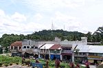
The Gombak District is an administrative district located in the state of Selangor, Malaysia. The district was created on February 1, 1974, the same day when Kuala Lumpur was declared a Federal Territory. Until 1997, Rawang was the district capital; the capital has been moved to Bandar Baru Selayang. Gombak borders Kuala Lumpur to the southeast and the Genting Highlands to the east. Both Gombak and Kuala Lumpur, along with some other districts in Selangor, are situated within the Klang Valley. Other localities that are situated in Gombak district include Batu Arang, Kuang, Rawang, Kundang, Gombak Town, Selayang, Batu Caves and Hulu Kelang. The International Islamic University Malaysia (IIUM/UIAM) main campus is also located here as well as the Batu Caves. Gombak is also home to an aboriginal Orang Asli settlement, and it is the site of the Orang Asli Museum. Gombak River merges with the larger Klang River in Kuala Lumpur. The meeting place of the two rivers is the birthplace of Kuala Lumpur. At the center of the confluence is the Masjid Jamek. Gombak (town) also refers to as a locality (town/area/suburb) in the northern and central portion of the Setapak subdistrict (both in Gombak and Kuala Lumpur). Before 1974, Gombak was a town before it became a district. Gombak was home to the settlements of the first Minangkabau immigrants in the 1800s and was established soon after. Old mosques in the Gombak area such as the Masjid Lama Batu 6 Gombak are still standing to this day. Today, Gombak can be referred to both the town and district itself but the locals usually refers Gombak as the town, not the district.
Excerpt from the Wikipedia article Gombak District (License: CC BY-SA 3.0, Authors, Images).Gombak District
Selayang Municipal Council
Geographical coordinates (GPS) Address Nearby Places Show on map
 Continue reading on Wikipedia
 Geographical coordinates (GPS)
| Latitude | Longitude |
|---|---|
| N 3.27425 ° | E 101.57072222222 ° |
Address
48050 Selayang Municipal Council
Malaysia
Open on Google Maps