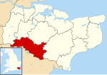
Royal Tunbridge Wells

Royal Tunbridge Wells is a town in Kent, England, 30 miles (50 kilometres) southeast of central London. It lies close to the border with East Sussex on the northern edge of the High Weald, whose sandstone geology is exemplified by the rock formation High Rocks. The town was a spa in the Restoration and a fashionable resort in the mid-1700s under Beau Nash when the Pantiles, and its chalybeate spring, attracted visitors who wished to take the waters. Though its popularity as a spa town waned with the advent of sea bathing, the town still derives much of its income from tourism.The town has a population of around 56,500, and is the administrative centre of Tunbridge Wells Borough and in the parliamentary constituency of Tunbridge Wells.
Excerpt from the Wikipedia article Royal Tunbridge Wells (License: CC BY-SA 3.0, Authors, Images).Royal Tunbridge Wells
Upper Grosvenor Road, Tunbridge Wells St James
Geographical coordinates (GPS) Address Nearby Places Show on map
Geographical coordinates (GPS)
| Latitude | Longitude |
|---|---|
| N 51.132 ° | E 0.263 ° |
Address
Well Tunnel (Tunbridge Wells Tunnel)
Upper Grosvenor Road
TN1 2DU Tunbridge Wells, St James
England, United Kingdom
Open on Google Maps


