place

Postwick with Witton

BroadlandCivil parishes in NorfolkNorfolk geography stubsPages including recorded pronunciations

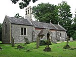
Postwick with Witton ( (listen)) is a civil parish on the Broads in the English county of Norfolk, comprising the two adjacent villages of Postwick and Witton. Postwick is some 4.5 miles (7.2 km) east of the city of Norwich, just south of the eastern end of the A47 Norwich southern bypass on the north bank of the River Yare. Witton lies 1.75 miles (2.8 km) to the north-east, north of the A47.The civil parish has an area of 8.29 km2 (3.20 sq mi) and in the 2001 census had a population of 323 in 128 households, increasing to a population of 404 in 162 households at the 2011 Census . For the purposes of local government, the parish falls within the district of Broadland.[1] Although the Wherry Lines rail line passes through Postwick, there is no station. In the west of the parish at the junction of the A47 and A1042 is Postwick Park and Ride, one of six such sites surrounding Norwich. A ferry once operated on the River Yare between Postwick and Surlingham. It ceased c. 1939 following a collision with a coaster

Excerpt from the Wikipedia article Postwick with Witton (License: CC BY-SA 3.0, Authors).

Postwick with Witton
Postwick Road, Broadland Postwick with Witton

Geographical coordinates (GPS) Address Nearby Places
placeShow on map

Wikipedia: Postwick with WittonContinue reading on Wikipedia

Geographical coordinates (GPS)

Latitude Longitude
N 52.625 ° E 1.4 °
placeShow on map

Address

Postwick Road

Postwick Road
NR13 5DU Broadland, Postwick with Witton
England, United Kingdom
mapOpen on Google Maps

Share experience

Nearby Places

Surlingham Church Marsh RSPB reserve

Surlingham Church Marsh is a small RSPB nature reserve in the Norfolk Broads, England. It is part of Yare Broads and Marshes Site of Special Scientific Interest Situated north of the village of Surlingham and south of the River Yare, it comprises 68 acres (28 hectares) of mixed wetland habitat including shallow open water, dykes, reed and sedge fen, and small areas of willow carr, as well as deciduous woodland on the southern margin of the reserve. A footpath of about 1¼ miles circumnavigates the reserve from Surlingham Church, down and along the river Yare and a hide overlooks a shallow pool within the reserve. There is a no fishing policy on the river bank within the reserve. Dogs are allowed but should be kept under control. Notable amongst the breeding birds are gadwall, shovellers, and reed, sedge, grasshopper and Cetti's warblers. Marsh harriers are regular visitors and occasionally breed. Migrants include Jack snipe and green sandpiper, and winter visitors include hen harriers and bearded tits. The reserve also supports several species of dragonfly, and a variety of butterflies, various other insects and invertebrates, and many species of wild flower, orchid, and particularly aquatic plants. Purchased in 1984 as a potential habitat for marsh harriers and bitterns, the reserve is now managed mostly for its fen plant communities and the invertebrates which feed off them. Water levels are managed by the use of a sluice gate. A small number of highland cattle summer graze on the fen to improve habitat quality and to assist with the removal of scrub from the fen. The naturalist Ted Ellis is buried at the nearby ruin of St Saviour's church.

Kirby Bedon
Kirby Bedon

Kirby Bedon is a hamlet in South Norfolk which lies approximately 3½ miles (5½ km) south-east of Norwich on the road to Bramerton. It covers an area of 7.82 km2 (3.02 sq mi) and had a population of 186 in 77 households at the 2001 census, the population increasing to 198 at the 2011 Census.The villages name means 'church farm/village'. The village was held by the Bidun family in the 12th century. It has two churches, the ruined round-towered St Mary's Church and, standing opposite, St Andrew's church, which is still in use. St Andrew's contains a plaque erected by parishioners in memory of four crew members of "Broad and High", an American B-24 Liberator bomber who were killed when it crashed near the church on 18 August 1944 as it returned to Rackheath from a raid on Germany.For one hundred years Kirby Bedon had a village school, which opened on 24 June 1878 and closed for the last time on 26 July 1978, a victim of the drive to close small village schools. Kirby Bedon has a historic link to the transatlantic slave trade through Sir John Berney (1757-1825) of Kirby Bedon Hall. He was the owner of Hanson Plantation, Barbados.The village no longer has a pub; the Stracey Arms on the main road from Norwich to Bramerton closed in 1967. It is now a Caravan Club certified location.Kirby Bedon Church Hall was the home venue of Kirby Bedon Short Mat Bowls Club from the late 1980's to 2017 when it disbanded. They were a very successful side which won the Norfolk Summer League on many occasions as well as many other cups and titles. They were the winners of the first ever National Club Championships in 2009. Kirby Bedon is linked to Norwich by bus route 85 operated by Our Bus providing nine services a day into Norwich and to the neighbouring villages of Bramerton, Surlingham and Rockland St Mary.