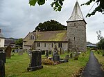
Wentnor
AC with 0 elementsCivil parishes in ShropshireShropshire geography stubsVillages in Shropshire

Wentnor is a village and civil parish in Shropshire, England. It lies to the west of the Long Mynd and between the village and the hill range is the dispersed settlement of Prolly Moor. The village itself is situated atop a hill, which rises to 269 metres (883 ft) above sea level, with the Criftin Brook to the east and the River East Onny to the west. The nearest towns are Church Stretton and Bishop's Castle, the village of Asterton lies 1 mile to the south east of the village. There is a parish church and two public houses: the "Crown" in the village itself and the "Inn on the Green" which is in a hamlet, just outside the village, by the River East Onny called The Green.
Excerpt from the Wikipedia article Wentnor (License: CC BY-SA 3.0, Authors, Images).Wentnor
Geographical coordinates (GPS) Address Nearby Places Show on map
Geographical coordinates (GPS)
| Latitude | Longitude |
|---|---|
| N 52.529 ° | E -2.91 ° |
Address
SY9 5EP
England, United Kingdom
Open on Google Maps


