The Bog

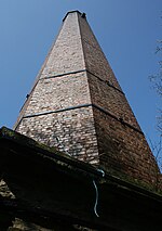
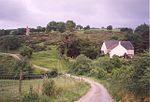
The Bog is a former mining community in Shropshire, England. It lies 6 miles (10 km) north of Bishops Castle, east of the A488, at grid reference SO355979. It was once a busy village with over 200 buildings. Now only a few remain. The local mines produced lead and barytes until the early 20th century. The mine at The Bog and the adjacent Stiperstones outcrop were only viable because of a geological movement; over time the movement of the tectonic plates landed at this site, combined with the movement of the earth it crumpled the layers and the softest layers were then eroded away. After mining stopped, the undisturbed remnants provided a range of wildlife habitats: birds nest in the old buildings, bats roost in the old mine tunnels, and reservoirs and ponds are ideal for aquatic life.
Excerpt from the Wikipedia article The Bog (License: CC BY-SA 3.0, Authors, Images).The Bog
Geographical coordinates (GPS) Address Nearby Places Show on map
Geographical coordinates (GPS)
| Latitude | Longitude |
|---|---|
| N 52.575 ° | E -2.951 ° |
Address
SY5 0NG , Worthen with Shelve
England, United Kingdom
Open on Google Maps


