place

John McLoughlin Bridge

1933 establishments in OregonBridges by Conde McCulloughBridges completed in 1933Bridges in Clackamas County, OregonBridges of the United States Numbered Highway System
Buildings and structures in Oregon City, OregonGladstone, OregonOregon building and structure stubsOregon transportation stubsRoad bridges in OregonSteel bridges in the United StatesTied arch bridges in the United StatesU.S. Route 99United States Numbered Highways stubsWestern United States bridge (structure) stubs
JohnMcLoughlinBridge

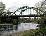
The John McLoughlin Bridge is a tied-arch bridge that spans the Clackamas River between Oregon City and Gladstone, Oregon, in the northwest United States. It was designed by Conde McCullough, and named for Dr. John McLoughlin. It is 720 ft (220 m) long, with a main span of 240 ft (73 m). The deck carries four lanes (two in each direction) of Oregon Route 99E, also known locally as McLoughlin Boulevard. The bridge won the American Institute of Steel Construction's title of "Most Beautiful Steel Bridge" constructed in 1933. Originally painted black, it was painted "ODOT Green" soon after, the first time that specific color was used on a bridge.

Excerpt from the Wikipedia article John McLoughlin Bridge (License: CC BY-SA 3.0, Authors, Images).

John McLoughlin Bridge
McLoughlin Boulevard,

Geographical coordinates (GPS) Address External links Nearby Places
placeShow on map

Wikipedia: John McLoughlin BridgeContinue reading on Wikipedia

Geographical coordinates (GPS)

Latitude Longitude
N 45.37322 ° E -122.60143 °
placeShow on map

Address

John McLoughlin Bridge

McLoughlin Boulevard
97027
Oregon, United States
mapOpen on Google Maps

linkWikiData (Q6248106)
linkOpenStreetMap (705793164)

JohnMcLoughlinBridge
Share experience

Nearby Places

Clackamas River
Clackamas River

The Clackamas River is an approximately 83-mile (134 km) tributary of the Willamette River in northwestern Oregon, in the United States. Draining an area of about 940 square miles (2,435 km2), the Clackamas flows through mostly forested and rugged mountainous terrain in its upper reaches, and passes agricultural and urban areas in its lower third. The river rises in eastern Marion County, about 55 miles (89 km) east-southeast of Salem. The headwaters are on the slopes of Olallie Butte in the Mount Hood National Forest, about 10 miles (16 km) north of Mount Jefferson, at an elevation of 4,909 feet (1,496 m) in the Cascade Range. The Clackamas flows briefly north and then flows northwest through the mountains, passing through North Fork Reservoir and Estacada. It then emerges from the mountains southeast of Portland. It joins the Willamette near Oregon City and forms the boundary between Oregon City and Gladstone. The Clackamas provides hydroelectric power and drinking water for some of the Portland metropolitan area, and it supports runs of Coho salmon, spring and fall Chinook salmon, and summer and winter steelhead. The river's old-growth forests, its habitat for several species of birds, its healthy fish runs, and the recreational opportunities that it provides—such as fishing and whitewater rafting—led to the designation of more than half of the length of the river into the National Wild and Scenic Rivers System (NWSRS). This environment also allowed Native Americans to settle in the river's basin as early as 10,000 years ago. Regulation of the river began in 1905 with the Cazadero Dam. In 1912, the River Mill Dam intercepted wood and coarse sediment. Later dams at North Fork, Oak Grove, Stone Creek, and Timothy Lake also intercepted wood sediment on the lower river.