place

Church of St Mary, Podington

Bedfordshire building and structure stubsChurch of England church buildings in BedfordshireEnglish church stubsGrade I listed churches in BedfordshireUse British English from February 2023
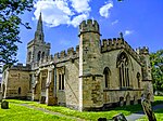
Podington, St Mary the Virgin (geograph 5472814)

Church of St Mary, or St Mary the Virgin, is a Grade I listed church in Podington, Bedfordshire, England. It became a listed building on 13 July 1964, (List Entry Number: 1321514). The National Grid Reference is SP 942 627.Surviving architectural elements date back at least to the early 13th century. A 1912 report about the church indicated that it had a chancel, nave, north aisle, south aisle, south porch and west tower. The south arcade of the nave, the north arcade the chancel and tower were all dated to the 13th century. There were four bells in 1912, dating from 1609 to 1618. The leaning spire was built in the 14th century but was modified in the 14th and 15th century. It was in danger of collapse but was restored in the 19th century.During the reign of Henry II, the church was part of the endowment to the Canons Ashby Priory by Stephen la Leye. During the Dissolution it became Crown property. In 1545, the advowson was granted to Daniel Payne. The church is the final resting place of Richard Orlebar the High Sheriff of Bedfordshire (died 1733) and his wife the culinary writer Diana Astry (died 1716), who had owned Hinwick House.The pipe organ was restored by the 92nd Bomb Group Memorial Association. The 92nd group had been stationed at the RAF Podington airfield during WW II and flew nearly 300 operational missions from that base.

Excerpt from the Wikipedia article Church of St Mary, Podington (License: CC BY-SA 3.0, Authors, Images).

Church of St Mary, Podington
High Street,

Geographical coordinates (GPS) Address Nearby Places
placeShow on map

Wikipedia: Church of St Mary, PodingtonContinue reading on Wikipedia

Geographical coordinates (GPS)

Latitude Longitude
N 52.2543 ° E -0.6218 °
placeShow on map

Address

High Street
NN29 7HP , Podington
England, United Kingdom
mapOpen on Google Maps

Podington, St Mary the Virgin (geograph 5472814)
Share experience

Nearby Places

Podington
Podington

Podington is a village and civil parish in Bedfordshire, England, United Kingdom. The village is within the electoral ward of Harrold in the Borough of Bedford. Podington lies around 16 km (9.9 mi) northwest of Bedford and is about 2 km (1.2 mi) east of the county border with Northamptonshire. Nearby there is paintballing. Podington Garden Centre, founded by village residents Colin & Norma Read in 1976 can be found in the High Street. Podington is a small picturesque rural village; many of its buildings are stone cottages dating from the 18th century, and some even earlier. Podington was included in the Domesday Book 1086, with a population of 29 households; prominent landowners included Walter of Flanders, Hugh of Flanders and William Peverer.The community was recorded as "Podintone" and "Potintone" from the 13th century and later as "Puddington". Today it is sometimes spelt (or misspelt) "Poddington". Located around 3 km (1.9 mi) southeast of the village are RAF Podington and Santa Pod Raceway. Hinwick House is found at a crossroads under 1 km (0.62 mi) south of the village. Church of St Mary is a Grade I listed church in Podington. It became a listed building on 13 July 1964. Some surviving architectural elements date back at least to the early 13th century. A 1912 report about the church indicated that it had a chancel, nave, north aisle, south aisle, south porch and west tower. The south arcade of the nave, the north arcade the chancel and tower were all dated to the 13th century.Mary I of England gave the manor to one of her servants George Brediman in 1557. Richard Orlebar, the High Sheriff for Bedfordshire and his wife, the culinary writer Diana Astry, were both buried at this church in the 1700s. They had been the owners of Hinwick House.The church's pipe organ was restored by the 92nd Bomb Group Memorial Association. The 92nd group had been stationed at the RAF Podington airfield during WW II and flew nearly 300 operational missions from that base.

Hinwick
Hinwick

Hinwick ( HIN-ik) is a hamlet in northwest Bedfordshire, England, United Kingdom; it is around nine miles north west of Bedford and is about 1 km (0.62 mi) east of the county border with Northamptonshire which is also the postal county. The hamlet is in the parish of Podington, which is sometimes called "Podington and Hinwick" and this parish was within the Hundred of Willey. Hinwick was recorded in the Domesday Book in 1086 as Haneuuich, also spelt Heneuuiche or Henewich and has also been recorded as Henewic and Hynewyk from the 13th century. In 1086, the population consisted of 19 households under six owners.The area had been inhabited for centuries by that time. Paleoliths (stone tools) have been found and there is an indication that Bronze Age cinerary urn was also found. Some evidence of Roman habitation was also discovered including pottery, building materials and animal bones. Today Hinwick is within the electoral ward of Harrold which is in the Borough of Bedford. Located around two miles south east of Hinwick are RAF Podington and Santa Pod Raceway. At the cross roads, to the north side of the hamlet is Hinwick House, a manor house in its own 36 acres of grounds, built in 1709–14; its Victorian wing was added in 1860. The house is Grade I listed; it was extensively restored in 2014–2016.Hinwick Numbers 1 and 2 (two houses) are Grade II listed, (Entry Number: 1114355). They were built around 1682 but modified since that time.According to the 2015/2016 Hinwick Conservation report, the community has changed significantly over the centuries, from primarily agricultural "to a predominantly residential commuter village". Some historically significant buildings remain however, including Park Farm House, West Farm House, the barn at West Farm, the Old Wheatsheaf and the Keepers Cottage.Less than one mile north north east along the main road is the village of Podington. Other nearby villages include, Farndish to the north and Wollaston to the north west, both just within two miles and also Bozeat around two and a half miles south west. The centre of the larger town, Rushden, is around three and a half miles north north east.